
Recent Topics
-
WEEKEND UPDATE
August 20, 2010 5:14 PM | No CommentsHey Folks,Happy Friday... alright time for an update on your weekend forecast... which in all honesty... could be much worse. Having said that, it's looking far from spectacular especially for Eastern Newfoundland.The Setup on Saturday... looks like this.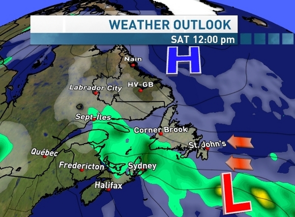 An Easterly flow will dominate on Saturday with winds sustained at 30 and gusting to 50 especially in the morning. It looks like the bulk of the Rain will stay to the South... with some showers along the South Coast... however the Eastern half of the Island will see lots of Cloud cover with periods of drizzle and fog... primarily in the morning hours. Overcast in the afternoon. Temperatures will struggle to get to 16 or 17.The Western part of the Island, may squeak out some sunny breaks... but I think the cloud cover will dominate there as well.An onshore flow up the Northern Peninsula and into South Eastern Labrador will keep things cloudy with some drizzle there as well.However up the Labrador Coast and into Happy Valley Goose Bay should be very nice... with a South Easterly flow on Saturday.Western Labrador is looking at plenty of cloud cover with a few showers, but much drier than you were today.SUNDAYSunday, Sunday, Sunday. As I mentioned on my twitter account today... the Canadian forecast model has been doing so much flip flopping on the Sunday forecast... it's making me quezzy! and yes frustrated as well.The Canadian model has been going back and forth on whether or not the steady rain will stay to the South of Newfoundland or whether or not those Rains will work right up through Eastern Newfoundland.Here's proof. This morning's run...
 This afternoon's run...
 The afternoon run is very similar to the afternoon American forecast model run. So for Eastern Newfoundland let's keep with the forecast of an Easterly flow... lots of Cloud cover... periods of drizzle... and a good chance of some showers. With the steady rains staying to the South Coast of Island. However this forecast comes with a big ol disclaimer!!If things play out this way... the rest of the Island is still in for a mostly cloudy Sunday... with a chance of showers... but nothing too wet.Showers in the forecast for Western Labrador in the morning... with likely some afternoon clearing. Once again Eastern Labrador is the place to be... Sun and Cloud.I'll again dry to drop a few updates on my twitter. www.twitter.com/ryansnoddonHave a great weekend.Ryan
 -
WEEKEND THOUGHTS
August 18, 2010 3:16 PM | No CommentsHey Folks,Just a quick update on the weekend...Last night I was mentioning on the show... we have a battle setting up... between Low pressure to the South and High pressure to North of the Island. At first, it was looking like our High was going to be able to at least PARTIALLY hold it's ground... with maybe a few showers sneaking through each day. However, in the more recent runs the forecast models have that High caving and allowing our Low to push right in from the South.In fact, we could see some moderate-heavy Rains coming in with this juicy Low. Not what you wanted to hear I know.Now, the forecast models are still having their differences about exactly when the Rains will arrive and just how far Northwest they'll be allowed to push in.Here's a look at the GEM Canadian model which is really caving with the area of High pressure... bringing in a decent shot of Rain on Saturday. This would also see us dealing with some lingering showers on Sunday. Now here's the GFS American model which keeps Saturday dry... but the Avalon could be looking at moderate Rain on Sunday. Which is shown below.
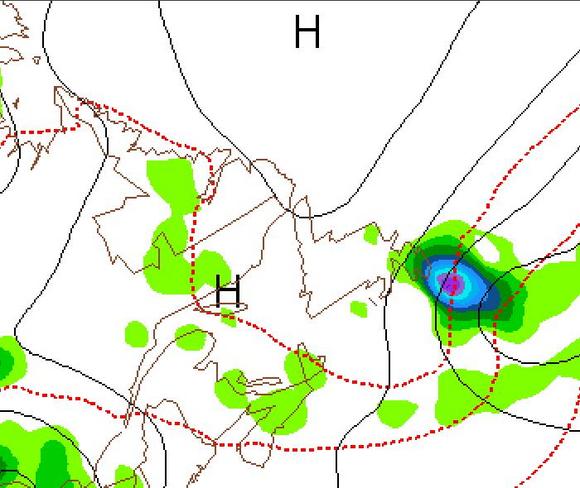 So again here we are, dealing with another GEM vs GFS showdown. Last weekend the GFS clearly had the right idea. However the GFS has been all over the place in the past 24 hours. In fact, this morning the GFS was pretty much the same as the GEM model, bringing heavy rain in on Saturday. Every run has been different, so I'm not holding to much faith in that model at this point. I should mention... that the European model is taking the system off to the Southeast and keeping us.. for the most part dry.I'll continue to watch and bring you the latest... however for now... the umbrella and rubber boots should be on the check list for this weekend... especially in Eastern Newfoundland.Ryan
 -
A LOOK AHEAD...
August 16, 2010 1:45 PM | No CommentsHey Folks.I hope you had a great weekend.... because I certainly did! I'm on a mini summer break from my Meteorology courses right now, so I'm trying to take full advantage of my weekends while I still can.
On Saturday we headed out to the Blueberry Festival in Brigus, which was an awesome time. And very tasty as well!! We then headed down to Ferryland for the Lighthouse Picnic on Sunday. What a day we had! The wind was a bit brisk in from the Northeast, but the sun was shining and you'll likely notice my nicely "toasted, but not burnt" face on the air tonight. lol.
 Alright, onto the Weather. For those of us here in St. John's and across the Avalon... today feels like Fall has started. Northeast winds, Rain & really cool temperatures. For those of you in Central and Western Newfoundland and up into Labrador... I hope you enjoyed your 25-30 degree heat and Sunshine today!!!Here are few points on the week ahead.-Tracking the Cold front: I'm keeping my eye on a Cold front pushing in from the West. Western Labrador will be the first to see the front this afternoon and this evening with showers pushing in. Those showers will move into Eastern Labrador and Western Newfoundland tomorrow afternoon... Central Nfld Tuesday evening, with Eastern Newfoundland likely getting into action overnight and into Wednesday.-Wednesday: At this point hump day looks to be the most unsettled day of the week from corner across the Province. Lots of cloud cover with showers in the forecast for everyone.-Clearing Thursday: Our system should nicely clear out of Newfoundland on Thursday... however it appears another system and Cold front will already be moving into Western Labrador for Thursday afternoon.-Friday and beyond: Forecast models are also showing a decent Low forming along the U.S. Northeastern Seaboard on Thursday morning and then tracking it Northward for Friday and into Saturday. Once again, we are back into our GEM vs GFS battle.-The GFS shows a decent pulse of moisture rolling up through Newfoundland on Friday night and into Saturday... with perhaps a bit of a clear out for Sunday.-The GEM however is stronger with an area of High pressure forming over Greenland and the Labrador Sea and as a result, pushes the same system off to the East on Saturday... with perhaps some showers for Eastern Newfoundland on Sunday.I'll watch things closely over the next few days... and keep you updated.It's also worth mentioning, late this week it appears things in the Tropics will once again heat up and we'll likely be talking about Tropical Storms again by this time next week... if not even earlier.
Ryan -
THE GEM VS THE GFS
August 13, 2010 6:04 PM | No CommentsTHE ULTIMATE SHOWDOWN!!!Hahaha... I feel like that last line should end with... only on Pay Per View!Alright, just a quick post about the battle going on between the GEM Canadian model and the American GFS models for our Sunday night/Monday and even into Tuesday forecasts.Now two forecast models having two different ideas on how things will play out... is nothing new. However usually as the day gets closer, one model usually starts to vary a bit... or lean towards the others thinking. This hasn't been the case over the past few days with these two suspects.There's a system brewing off to the South of Newfoundland, that system will work North through out the weekend and move towards Southeastern Newfoundland by Sunday. Now the question is, will the area of High pressure over the Island this weekend, be able to hold strong Sunday and into Monday? Or will that area of High pressure cave and allow this Low to push from the Southeast?GEM MODEL- Clearly is going with the caving idea... in fact the latest run is building the cloud cover into Eastern Nfld on Sunday with showers moving in late in the afternoon and evening. GFS MODEL- Is holding strong with the High.
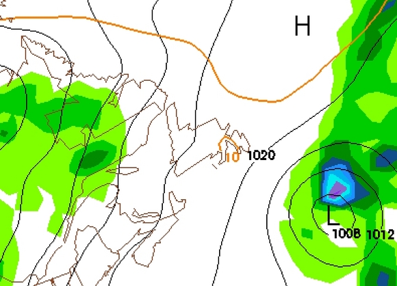 Personally, I think we could end up somewhere in between... with the Low edging in close enough to bring us some showers overnight on Sunday, into Monday and maybe into Tuesday. Some of the other forecast models are also leaning towards this "in between" idea.I'm have a crazy busy weekend on the way... but I'll try to drop you an update on my twitter.Have a great weekend.Ryan
 -
FROST, METEORS AND SUNSHINE!
August 12, 2010 1:54 PM | No CommentsHey folks,So tonight is going to be a very interesting night across the Province... especially in Newfoundland.An area of High pressure, which is moving in from the Polar regions, is sinking into the Province today. It's cooling temperatures, clearing the skies, and calming the winds. And that my friends, is the perfect setup for FROST! Now it looks like Labrador should be fine... and Coastal sections of the Island should say frost free as well. However, inland and low lying areas are definitely at risk of seeing Frost tonight. Safe to say if you're headed outside overnight, bundle up. EC may issue Frost Warnings later this afternoon... if they do I'll let you know on Twitter. www.twitter.com/ryansnoddonSo why would you head outside overnight anyway??? The Perseid Meteor Shower of course!!!Yes, astronomers and sky gazers must be licking their lips at the thought of tonight. Not only will it be the peak of the Perseid Meteor shower, but Venus, Saturn, Mars and the crescent moon will also make appearances in the night sky.The best time to spot the planets and the moon will be just after Sunset... and before they disappear beyond the horizon after 10pm. You'll want to be looking SSW for that.However the real show will be in the Northern Sky between midnight and about 4 am before the Sun starts to brighten things up again. Again for the best results, head away from the City lights. For more on the Perseid Meteor showers check out this page by NASA.Of course, the major factor on whether you'll be able to catch a glimpse of the meteor shower is the weather! Conditions will be perfect for much of the Province, including Western Newfoundland, Central Newfoundland and Western Labrador. It looks like up the Coast of Labrador could be a little on the Cloudy side as well as in Happy Valley-Goose Bay where it appears the Clouds will likely dominate.The question mark will be the Avalon where the forecast models are clearing the cloud cover through the Overnight... however timing is everything. In fact here's a shot of 3 am across the Province and you can see the GEM Canadian model is holding some cloud cover along the Southern Shore. The American models have the same idea.
 It looks like the better chance will be very early in the morning as opposed to very late tonight. The afternoon model runs should have a better handle on it... and I'll update you tonight on Here & Now.WEEKEND LOOKING GOODAs I mentioned, this area of High pressure is moving in and clearing us out, in fact Friday, Saturday, Sunday and MAYBE even into Monday are looking very nice across the Province. Some forecast models... including the American GFS are actually holding this ridge across Newfoundland right through mid next week! However, you see that Low off to the Southeast of Newfoundland? Well, the Canadian model is now bringing that Low into Newfoundland on Monday instead of keeping it offshore... so stay tuned on that.
 None the less... the weekend is still looking good for everyone... with perhaps just some cloud cover pushing into Labrador along a warm front on Sunday.Ryan
 -
COLIN IS DEAD
August 9, 2010 2:14 PM | No CommentsHey Folks,I hope you had a great weekend.
Well, as I mentioned on the blog yesterday, Colin was ripped apart in the Atlantic this weekend and now sits as an elongated trough of Low pressure. His remnants stretch from Southern Nova Scotia, south all the way to Bermuda. In the end, Colin's slow movement and strong wind shear did him in... at one point on Friday and again on Saturday he was completely stalled out... moving 0 km/h. With the wind shear overhead and the dry air wrapping into the system, he dissipated quite quickly on Saturday and then Sunday. I'm actually pretty surprised at how poorly the forecast models handled the system, even yesterday some of the Hurricane models were showing re-intensification... something that was quite clear... wasn't going to happen. Having said that, Hurricanes and Tropical Storms are pretty much of the hardest systems to predict and forecast in the world of weather... and they form in the ocean... where there is a lot less data to go on.Alright, so the remnants of Colin will continue to track Northward this week and it appears Eastern Newfoundland will see pretty cloudy skies with showers on Tuesday, Wednesday and Thursday as a result. However, it looks like the heaviest rain from what's left of Colin will track to the East and fall offshore.THIS WEEK-Generally, a pretty cloudy and damp week overall across the Province. With what's left of Colin in the East PLUS the system parked over Labrador today and it's lingering Cold front... it appears we're in for an unsettled week... and things could be a little on the cool side as well. Yes... I'm full of good news aren't I?-Our relief is an area of High pressure currently parked over Hudson Bay... however it's going to take a few days to get here. Maybe that will prove to be a good thing, because right now it's arrival is timed for Friday and into the weekend.I'll keep ya posted.
Ryan