-
Thu Oct 22 2015
Posted at 10:49 AM
Share your autumn photos with #StarWeather
Are you drinking a pumpkin spice latte? Did you just have an autumn leaf war with your friends? Snap a pic and tweet/Instagram it to us using the hashtag #StarWeather.
It's that crisp time of year again when cable knit sweaters become a staple in your wardrobe and baristas insist on up-selling you new, limited-time lattes that taste like melted Halloween candy.
While mornings are slightly chilly, Torontonians should relish this fresh fall weather before winter sets in. Expect snowfall in November, though snow already arrived for some Ontarians halfway through October. El Nino could increase the risk of ice-storms in eastern Ontario and Quebec. The bright side? Accuweather says Toronto can expect milder temperatures this winter.
In the meantime, enjoy the onslaught of fall-friendly Instagram photos and tweets to come. Are you drinking a pumpkin spice latte? Did you just have an autumn leaf war with your friends? Snap a pic and tweet/Instagram it to us using the hashtag #StarWeather. We'll share them here!
Read full story
-
Sat Oct 17 2015
Posted by Jackie Hong, Staff Reporter at 12:26 PM
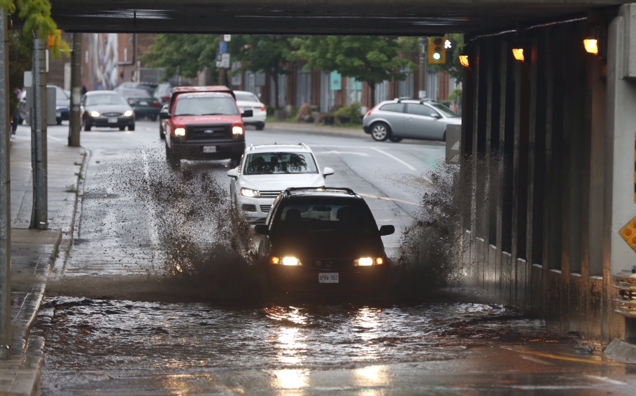
Snow has arrived – and some Ontarians are not loving it
Environment Canada has also issued a number of snow squall warnings and frost advisories for portions of southern Ontario

Courtesy Twitter user Colleen Rose
Yes, that's snow on the ground in Red Rock, Ont., Saturday morning.
We’re only halfway through October but some places in Ontario are already seeing the white stuff.
And looks like there’s more on the way – Environment Canada has issued a handful of snow squall warnings and frost advisories for portions of southern Ontario. Toronto has a 30 per cent chance of seeing rain or flurries Saturday evening, so the city may be seeing snowflakes way sooner than anyone wanted to.
Read full story
-
Fri Oct 16 2015
Posted by Brennan Doherty at 10:52 AM
Snow flurries on marathon Sunday?
Environment Canada says there's a 30 per cent chance of rain or snow as the city hosts marathon runners from around the world.

Rick Madonik/Toronto Star
The Scotiabank 2014 Toronto Waterfront Marathon had more than 26,000 participants from 50 countries competing.
Attention, runners in this weekend's Scotiabank Waterfront Marathon runners: pack your wool socks. You may be battling snow as well as your time in this year’s race. Environment Canada is calling for a 30 per cent chance of either rain or flurries on Sunday, with a high of 8 C and a low of just 1 C. And Saturday isn’t looking too warm, either—a high of 6 C with a 40 per cent chance of flurries all afternoon and into the evening.
Read full story
-
Tue Oct 13 2015
Posted by Brennan Doherty at 03:20 PM
Rogers Centre roof closed for Game 5 of ALDS between Blue Jays and Rangers
Spokespeople for the MLB and the Toronto Blue Jays said they won't be making a decision on the Rogers Centre roof until Wednesday morning, depending on the weather.

David Cooper/Toronto Star
The Rogers Centre roof will be closed on Wednesday for Game 5 of the ALDS between the Toronto Blue Jays and Texas Rangers.
Due to cold temperatures, the roof at the Rogers Centre will be closed for Game 5 of the American League Division Series Wednesday, according to Stephen R. Brooks, Sr. Vice President of the Blue Jays.
“It’s about roof mechanics not fans toughening out the cold weather”, Brooks tweeted Tuesday. “It risks shutting down and never working again.”
Read full story
-
Fri Oct 02 2015
Posted by The Canadian Press at 11:02 AM
Canadian storm experts track Hurricane Joaquin
If Joaquin moves into Carolinas, Canadian Hurricane Centre says it could bring rainfall to southern Ontario, Quebec and Atlantic Canada

AP Photo/Ben Fox
The sky is overcast and streets mostly deserted on south Eleuthera island, Bahamas, early Oct. 2 as Hurricane Joaquin dumps torrential rains across the eastern and central Bahamas.
HALIFAX — The Canadian Hurricane Centre says it is monitoring hurricane Joaquin, which may move into Canadian waters early next week.
The storm is battering the central Bahamas with torrential rains that flooded homes and forecasters warned that the “extremely dangerous” Category 4 storm could grow even stronger as it roared along a path that could take it near the U.S. east coast.
The Halifax-based Canadian Hurricane Centre says there’s a high degree of uncertainty around the storm’s track forecast.
It says there are two particular scenarios, one that would have it moving into the Carolinas and the other showing it far offshore from Atlantic Canada.
Read full story
-
Thu Oct 01 2015
Posted by Ramisha Farooq and Evelyn Kwong Staff Reporters at 05:25 PM
September 2015 sees the warmest temperatures since 2002
Environment Canada says the influx in heat in September has to party do with the “super El Niño” that is warming up the Pacific Ocean leading into the Great Lakes causing a warming affect on the rest of the city.

Cole Burston/Toronto Star
A warm September in Toronto was welcomed by both joggers and fisherman.
If it felt like a warmer than usual September, it was.
Throughout last month, temperatures stayed well above the seasonal high of 21C.
Environment Canada says the influx in heat had partly to do with the “super El Niño” that is warming up the Pacific Ocean leading into the Great Lakes causing a warming affect on the rest of the city.
Temperatures in October will drop back slightly and remain closer to seasonal temperatures throughout the month seeing an average high of 14C and a low of 9C.
Read full story
-
Thu Oct 01 2015
Posted by The Canadian Press at 10:41 AM
Thousands lose power as rainstorm sweeps Maritimes
Downpour and subsequent washouts force closure of schools and cancel buses with more than 100 millimetres in some areas

THE CANADIAN PRESS/DARREN PITTMAN
A mini-van splashes through a rain puddle in Elmsdale, N.S., on Oct.1. Heavy raiins hit much of the Maritimes.
HALIFAX — Thousands of power customers in the Maritimes awoke to no electricity Thursday after a major rainstorm swept through the region.
Environment Canada said more than 100 millimetres of rain fell over parts of New Brunswick, including 168 millimetres reported at Kouchibouguac.
New Brunswick Power reported more than 5,000 outages Thursday morning, with most in the area around Fredericton.
The downpour and subsequent washouts forced the closure of some schools and cancelled buses. The province’s Emergency Measures Organization urged vigilance on its Twitter feed.
Read full story
-
Tue Sep 22 2015
Posted by The Canadian Press at 12:10 PM
'Monster' El Nino set to bring high tides, erosion to west coast: Researcher
The same study also warns a La Nina that is likely to follow later could slam B.C. with storms.

Kathleen Kenna for the Toronto Star
Driftwood piles on Vancouver Island's southwestern beaches.
A “monster” El Nino weather system expected to hit Canada’s West Coast later this fall and winter could lead to higher tides, flooding and erosion in low-lying coastal areas, says a professor at the University of Victoria.
Ian Walker’s warning comes out of part of a larger study by a group of researchers from five countries bordering the Pacific who looked into El Nino and La Nina weather systems. The study was published this week in the journal Nature Geoscience.
Thirteen researchers from universities and government agencies tried to determine if patterns in coastal change, such as erosion and flooding, could be connected to major climate cycles, like El Nino and La Nina, across the Pacific.
Walker, a geography professor whose specialties include beach and dune systems, coastal erosion and climate-change impacts, said he contributed data collected from the west coast of Vancouver Island, between Tofino and Ucluelet.
Read full story
-
Mon Sep 21 2015
Posted by Jackie Hong, Staff Reporter at 10:06 PM
Temperature rollercoaster ahead for fall in Canada
According to The Weather Network's Fall Forecast, we're in for a temperature ride this fall.

Vince Talotta/Toronto Star
People take a stroll through High Park on a cool and wet fall day. (Star file photo).
Hope you like wild rides, because we're about to be thrown on one during the fall weather forecast this year.
Although temperature fluctuations are normal for the season, “this year, Canadians should expect more prolonged periods than usual in which temperatures are either above or below normal,” said Chris Scott, chief meteorologist at The Weather Network.
According to the forecast, central and eastern Canada are in for a warmer-than-normal start to the fall (officially Wednesday) with temperatures possibly even hitting mid-summer levels before suddenly plunging into a false start to winter sometime in October. Around the Great Lakes, the low temperatures will mean a, “higher than typical threat for a significant autumn snowfall” paired with “a couple rounds of early-season lake-effect snow,” the forecast says.
The west coast will be hanging on to mild temperatures for a little longer, but no need for jealousy – by late fall, temperatures are expected to drop across the country and stay below average for several weeks before returning to seasonal weather in November or early December.
Read full story
-
Thu Sep 17 2015
Posted by thestar.com at 10:05 AM
Fall arrives Wednesday. Fall temperatures arrive this weekend
The Autumn Equinox is the official start to sweater and stews season, so enjoy wrining out the last few days of summer.

DALE BRAZAO/TORONTO STAR
The lake at the Beaches glows red at sunrise Thursday.
Fall officially arrives next Wednesday. Fall temperatures arrive this weekend.
While we bask in this week’s heat and wring out some more patio days, the Farmer’s Almanac is providing details of what’s to come. The autumnal equinox arrives at 4:21 a.m. on Sept. 23.
The equinox marks the point at which the Sun appears to cross the celestial equator from north to south. Nighttime temperatures, which have already been lower, drop even further and the leaves change colours in profusion.
So while we have a high forecast for 28C on Friday, the Sunday high is supposed to be only 18C — with a nighttime low of 10C after a downpour through Saturday.
Read full story
-
Sun Sep 13 2015
Posted by Fakiha Baig Staff Reporter at 03:47 PM
Sweater weather? Toronto temperatures set to cool
It may be time to layer up as temperatures are expected to drop to the mid-teens on Sunday.

DALE BRAZAO/TORONTO STAR FILE PHOTO
A family of swans nestles in the calm waters of Ashbridge's Bay in the Beach as the fall color begins tinging nearby trees.
Grab a sweater because cool fall-like temperatures are lingering over Toronto this cloudy Sunday.
There will be some sunny breaks this afternoon at 17 C, with humidity up to 77 per cent. Temperature will be falling to 15 C in the evening and 13 C overnight.
However, this won’t last too long. The rest of the week will be bright and sunny as temperatures will be rising to an average of 25 C during the day.
You may want to keep a sweater nearby for the evening, however, because the average overnight low for the rest of the week is 17 C.
Read full story
-
Fri Sep 11 2015
Posted by Brennan Doherty, Staff Reporter at 11:57 AM
Toronto gets taste of fall weather this weekend
But the weekend’s cool spell isn’t going to last.

DAVID COOPER/TORONTO STAR FILE PHOTO
Feels like fall: Toronto is in store for cool and wet weather this weekend.
Fall is in the air this weekend in Toronto — but it’ll only be a taster.
The thermometer isn’t expected to rise above 24 C Friday, with almost no humidity. There’s a 30 per cent change of overcast skies and occasional showers this afternoon, increasing to 60 per cent later this evening.
If you’re heading to TIFF this weekend, think of bringing along an umbrella and a sweater. Saturday is expected to be gloomy and grey, with a 60 per cent change of showers, a daytime high of 18 C and an overnight low of just 11 C. Sunday’s forecast is looking similarly dreary: a high of 17 C and a low of 11 C with a 40 per cent chance of showers.
Thankfully, the weekend’s cool spell isn’t going to last. Expect to see daytime highs of 26 C and mostly sunny skies for Monday through to the weekend. While it won’t feel like 40 C, the humidex is also expected to creep up on Tuesday, making it feel closer to 29 C.
Read full story
-
Tue Sep 08 2015
Posted by Michael Yang and Brennan Doherty, Staff Reporters at 11:30 AM
It’s back to school, so where’s the fall weather?
An extreme heat alert is in effect for Toronto Tuesday but relief is on the way.

Marta Iwanek/Toronto Star file photo
Not a good day for new back-to-school shoes: Muggy weather and thunderstorms are in store for students on their first day.
Although the end of summer is finally here for children and teens, it sure doesn’t feel like it just yet in Toronto. Labour Day’s hot, muggy weather is sticking around for a couple of days at least with an extreme heat alert in effect Tuesday as the kids head back to school.
The high for Tuesday is a sizzling 30 C — 37 C with the humidex — with a chance of thundershowers extending all day and into the early evening. Rain is also in the forecast for most of the day and into tomorrow morning. Wednesday’s expected high is 27 C.
The City issues an extreme heat alert when 31 C weather lasts three days or more, which activates the opening of seven cooling stations across Toronto. Open from 11 a.m. to 7 p.m. today, the stations provide water and light snacks to residents looking for some relief.
Officials recommend that everyone drink plenty of water, wear comfortable clothing and keep cool throughout the day.
Read full story
-
Sun Sep 06 2015
Posted by Laura DaSilva at 08:31 PM
Heat warning in effect for Labour Day
Sunny skies and a high of 33 C will mark the unofficial end of summer in Toronto.

Karen McKenna/file photo
Bellevue Beach offers a cool escape from the scorching sun. A heat warning remains in effect Labour Day in Toronto.
Don’t work too hard out there on Labour Day; it’s going to be a scorcher.
Sunny skies and a high of 33 C will mark the unofficial end of summer in The Six.
Environment Canada’s heat warning remains in effect after a sizzling weekend.
Be sure to stay hydrated and take breaks from the heat by spending time in air-conditioned spaces or in the shade.
Read full story
-
Sat Sep 05 2015
Posted by Stephanie Werner at 02:35 PM
It feels like 40 C right now in Toronto
This Labour Day long weekend, don’t expect The Six to be anything less than scorching.

AP Photo/Journal Inquirer, Jim Michaud
In this file photo, a very hot and thirsty dog named Buck cools off drinking bottled water poured by his owner Sue Anderson of South Windsor Conn., during a legion baseball game at the peak of the heat Wednesday afternoon, July 20, 2011, in South Windsor.
This Labour Day long weekend, don’t expect The Six to be anything less than scorching.
Toronto's Medical Officer of Health issued a heat alert on Saturday. This comes on the heels of Environment Canada’s heat warning of several days of 30 C temperatures for the city, issued Friday.
For the city, heat-related alert triggers include temperatures greater or equal to 31 C, lows less than or equal to 20 C, and a humidex greater than or equal to 40 C. If this is sustained for two days, the city issues a heat alert. If the hot weather lasts three days, the medical officer of health will issue an extreme heat alert, which activates the opening of seven cooling centres.
You can learn more about the Harmonized Heat Alert and Response System (HARS) here.
Read full story
-
Fri Sep 04 2015
Posted by Stephanie Werner at 03:05 PM
Heat warning issued for Labour Day long weekend
Toronto can't beat the heat. Temperatures reaching 30 C are expected for the last long weekend of summer.
Leading into the final long weekend of summer, Toronto has been issued a heat warning by Environment Canada.
The warning was issued at 2:16 p.m. with temperatures climbing to 27 C, or 31 C with humidity.
According to Environment Canada, Toronto should expect several days of maximum temperatures reaching 30 C starting Saturday which will continue through to Labour Day. Temperatures overnight are not expected to drop below 20 C.
As always, be sure to drink plenty of water – even before you feel thirsty.
Read full story
-
Fri Sep 04 2015
Posted by Sean Wetselaar, Staff Reporter at 07:08 AM
Hot weather to continue through Labour Day
After an unusually hot week late in August, Toronto can expect more temperatures above 30 C this September long weekend.

Brian B. Bettencourt/Toronto Star
Alice Wennington enjoys a book by a dock at the Beaches early this week. The last long weekend of the summer promises to be unusually hot.
After an unusually warm week, we can expect more heat as we head into the last long weekend of the summer.
Environment Canada predicts sunny skies with a high of 28 C on Friday .
Saturday looks to be sunny in the morning and early afternoon, with a 40 per cent chance of showers late in the afternoon, and a risk of thunderstorms with a high of 30 C.
Sunday and Monday will bring dryer conditions, with a high of 32 and 30 C respectively.
Read full story
-
Wed Sep 02 2015
Posted by Stephanie Werner at 10:44 PM
Toronto hits record temperature ahead of long weekend
Wednesday proved to be our hottest day of 2015 thus far. What does the long weekend hold?

Darren Calabrese/The Canadian Press
Toronto residents were likely seeking various ways to escape the heat, as temperatures hit a 2015 record high of 33.3 C at Pearson International Airport Wednesday.
Looks like the Toronto Blue Jays aren’t the only thing burning up Toronto this week.
Temperatures rocketed to a 2015 record high of 33.3 C at Pearson International Airport Wednesday. Around 5 p.m. the humidex topped out at a “feels like” temperature of 40 C – making sure that your commute home was nice and sticky.
While last month may have felt warm – and it was – the mercury never reached above 32.6 C. Toronto’s all-time record temperature for Sept. 2 was set in 1953 at 36.7 C, according to Environment Canada.
But Wednesday is hump day and that means looking ahead to the long weekend. Thursday and Friday are expected to hover around highs of 26 to 27 C to get you through the rest of your work week, with a brief fog patch dissipating on Thursday morning to accompany how you really feel.
Read full story
-
Thu Aug 20 2015
Posted by Holly Honderich Staff Reporter at 11:05 AM
Environment Canada ends special weather statement

DONNA LYPCHUK/CANADIAN PRESS
A major storm cloud moves over Etobicoke on Sunday, Aug. 2. Environment Canada is forecasting thunderstorms and heavy rain for today. The photographer said the image has a yellow filter from an in-camera editing program.
Environment Canada has ended its special weather statement for rain showers that were expected to drench the city today. In a statement issued at 9:13 a.m. Thursday, the agency warned about early morning rain and then heavy showers and thunderstorms are forecasted for this morning and afternoon with local rainfall amounts reaching between 30 and 50 mm.
Read full story
-
Tue Aug 18 2015
Posted by Jason Samenow Washington Post at 12:41 PM
July looks like the hottest month ever on Earth
NASA and the Japan Meteorological Agency data show last month was the hottest July on record. When all the data is in, that makes it likely it will be the hottest ever.

Japan Meteorological Agency graphic
For planet Earth, no other month was likely as hot as this past July in records that date back to the late 1800s. And the globe is well on its way to having its hottest year on record.
Both NASA and the Japan Meteorological Agency (JMA) have published data that show it was the hottest July on record. Since July is on average the planet’s warmest time of year, it’s fair to say temperatures this past month were at or very close to their highest point in the history of instrumental records.
NASA’s map of July temperatures shows large areas of much warmer than normal temperaturesEND in the Pacific Northwest, Western Europe, central Asia and Africa. It also reveals the telltale signature of the powerful El Niño event, portrayed by the much warmer than normal sea surface temperatures in the eastern and central tropical Pacific.
The heat from El Niño not only manifested itself over the tropical Pacific, but also likely boosted temperatures in other areas due to its ripple effects on global weather patterns. In sum, NASA data reveal July 2015’s average temperature edged July 2011 as the warmest on record (by 0.02 degrees), making back-to-back months of record-setting temperatures after a toasty June. Every month this year has ranked among the top four warmest in NASA’s analysis.
Read full story
-
Mon Aug 17 2015
Posted by Jackie Hong, Staff Reporter at 04:34 PM
7 things you probably didn't know about the Humidex
The humidex is a Canadian creation first used in 1965, according to Environment Canada’s website. It combines the temperature and humidity levels into one value that shows the perceived temperature, or how the heat and humidity feels “to the average person.”
Ah, the humidex. The thing that can make a summer day in Toronto go from a hot 31C to feeling like a stifling 39C. The city, and most of Ontario, has been hit with heat warning after heat warning this summer, in part thanks to a value that can make what could be a pleasantly warm day feel like the Sahara instead.
But what exactly is the humidex, anyway?
The humidex is a Canadian creation first used in 1965, according to Environment Canada’s website. It combines the temperature and humidity levels into one value that shows the perceived temperature, or how the heat and humidity feels “to the average person.”
Read full story
-
Sun Aug 16 2015
Posted by Sean Wetselaar, Staff Reporter at 09:44 PM
Man fries egg on driveway in heat wave that won’t let up anytime soon
It was so hot Sunday that Andy Wood, a Toronto YouTuber, decided to fry an egg on a driveway. And there's more heat on the GTA horizon, too.

YouTube
A video posted to YouTube shows Andy Wood crack the egg, leaving it for around two hours. By the end, though the egg white has been absorbed into the ground, the yolk has been nicely cooked.
It’s been another blisteringly hot day in Toronto, with a heat warning issued for the second consecutive day, and temperatures in the low 30s (37-40C with humidex).
It was so hot Sunday that Andy Wood, a Toronto YouTuber, decided to fry an egg on a driveway.
A video posted to YouTube shows Wood crack the egg, leaving it for around two hours. By the end, though the egg white has been absorbed into the ground, the yolk has been nicely cooked.
Read full story
-
Sat Aug 15 2015
Posted by Stephanie Werner, Staff Reporter at 04:28 PM
Summer heat set to return to Toronto
Environment Canada has issued a heat warning for southern Ontario: expect Sunday and Monday to feel close to 40 C.

Cole Burston/Toronto Star
Brace yourself for another Toronto heat wave. Sunday and Monday are forecast to soar past 30 C.
Be careful what you wish for.
A heat warning has been issued by Environment Canada for Toronto and all of southern Ontario.
During a soggy month where we’ve seen more rain than sun – only five days in August are on record as completely dry – many Torontonians were left asking where our summer went.
Well, we finally found it: Sunday and Monday.
Read full story
-
Fri Aug 14 2015
Posted by Stephanie Werner Staff Reporter at 03:47 PM
As Billie Holiday sang, 'Keeps rainin' all of the time.'
We're half way through August, and Greater Toronto has experienced more precipitation than it got during the whole month last year.

Donna Lypchuk/The Canadian Press
Rain clouds put on a show over Etobicoke August 2. As Billie Holiday sang in "Stormy weather," "Keeps rainin' all of the time."
It’s Toronto’s signature pastime. Not baseball. No, not enjoying a cold one on the patio either.
It’s complaining about the weather. And today, that’s warranted.
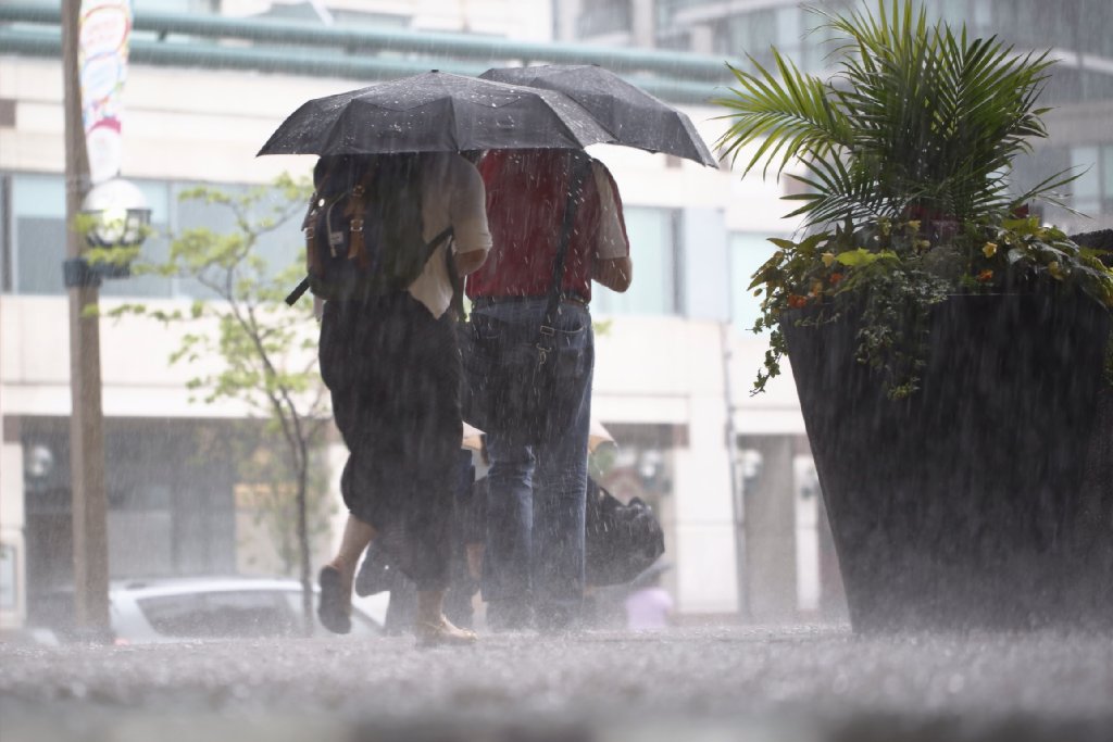
Mid-August typically brings visions of a day at the beach, but Friday evening you may not need to go swimming to get wet. Environment Canada has issued a special weather statement for much of Southern Ontario forecasting scattered thunderstorms and significant rainfall this afternoon.
“With a moist air mass in place over Southern Ontario, torrential downpours are a concern,” reads the statement in part. “Some of these thunderstorms may be capable of producing rainfall amounts of 30 to 40 mm. Should several thunderstorms track over the same area, rainfall amounts near 50 mm may be possible.”
Read full story
-
Mon Aug 10 2015
Posted by thestar.com at 01:27 PM
Hail destroys Delta plane nose, leads to emergency landing
Grounding is the latest in a string of similar incidents involving damage caused by hail to commercial aircraft.

Beau Sorensen via AP
Delta Airlines flight from Boston made an emergency landing in Denver because hail damaged the plane.
The U.S. Federal Aviation Administration says a Delta Airlines flight that originated from Boston made an emergency landing in Denver because hail damaged the plane.
The hail damaged the nose cone and windshield of the Delta flight on Friday.
It’s the latest in a string of incidents involving hail damaging aircraft.
In late July, an American Airlines flight bound for Dallas/Fort Worth was forced to return to Beijing after a hailstorm damaged the nose of the Boeing 787 Dreamliner, the Dallas Business Journal reported. Earlier in the month, a Delta Boeing 747 was damaged in a hailstorm over China and was forced to land in Seoul. The jet was subsequently taken out of service.
Read full story
-
Thu Jul 30 2015
Posted by Riannon Westall at 07:19 PM
Environment Canada ends heat warning for Toronto
Friday will reach a high of 30C, but there’s a 40 per cent chance of showers with a risk of a thunderstorm in the afternoon and evening. A low of 16C is expected.
After days of the scorching sun, Environment Canada has ended the heat warning for Toronto Thursday night.
Friday will reach a high of 30C, but there’s a 40 per cent chance of showers with a risk of a thunderstorm in the afternoon and evening. A low of 16C is expected.
With a chance of showers on both Saturday and Sunday, it could be a rainy weekend. Temperatures will dip down on Saturday, with a high of 25C and a 30 per cent chance of showers. Sunday will be similar with a high of 26C and a 30 per cent chance of showers.
Read full story
-
Wed Jul 29 2015
Posted by Diana Hall, Staff Reporter at 09:11 PM
Toronto cooling centre attendance might not be so hot
Representatives from the city of Toronto and Toronto Public Health weren’t available for comment about the demand for the cooling centres or whom they target.

Richard Lautens/ Toronto Star
It was so hot, Laura Grogan couldn’t breathe.
Grogan, 58, had hardly slept Tuesday night, so she knew by 8 a.m. that Wednesday was going to be a scorcher.
She spent the night and early morning hanging around Toronto East General Hospital because it had air conditioning and allowed Grogan, who is homeless, to catch up on the news.
Then, she rinsed and cooled off her feet in the lawn sprinklers that came to life nearby.
Read full story
-
Wed Jul 29 2015
Posted by Craig Desson, Digital Producer at 01:48 PM
Is it really that hot? How the heatwave compares with other years
Toronto's high temperatures this week are not quite record levels but yes, they are hotter than average

Marta Iwanek/Toronto Star
A woman walks near Flemington Park with a pink umbrella in Toronto, July 28, 2015. Environment Canada issued a heat warning for the city.
Today's weather is almost record breaking. Today's 34 C is close to the record high of 35.6 C set in 1949. To get some perspective on how today's highs compare to previous years, here are two charts based on figures from the Enviroment Canada almanac.
Read full story
-
Wed Jul 29 2015
Posted by Tania Pereira Digital Producer at 01:08 PM
9 sunshine spots around the world where it's cooler than Toronto
Bask on the beach in Algarve? Pose with Mickey at the Magic Kingdom? It's warmer here.
Read full story
-
Wed Jul 29 2015
Posted at 10:28 AM
Cool in the city: A guide to water fountains throughout Toronto
Click on the dots to find exactly where the city of Toronto has drinking fountains waiting to handle your thirst.
Environment Canada says water is the best way to hydrate yourself during a heatwave. The city's map shows the fountains that were working when it put together the guide.
William Davis Toronto Star Source: City of Toronto
Read full story
-
Wed Jul 29 2015
Posted by Stephanie Werner Staff Reporter at 08:06 AM
Emergency measures kick in as Toronto issues extreme heat alert for July's hottest day
Cooling centres will open at 11 a.m. today and eight swimming pools extend evening hours with the forecast calling for an expected high of 34 C.

Toronto Star File Photo
Don't stay out in the sun for too long. Toronto has issued an extream heat alert and opened cooling centres across the city.
We may be entering the hottest day of 2015.
Temperatures are expected to soar as high as 34C around 4 p.m., which may feel more like 40C with the Humidex.
An Extreme Heat Alert has been issued for Toronto which means that cooling centres will open at seven places. As well, the city is extending hours at eight swimming pools so people can cool off with an evening dip.
Here are the cooling centres:
Read full story
-
Tue Jul 28 2015
Posted by Luke Simcoe Metro Toronto News at 08:29 AM
True or False: 7 facts and myths about beating the heat
Does eating spicy food help? Downing sports drinks? Take this test

Jean-Philippe Ksiazek/AFP Getty Images
This lemur at the Sant-Martin-la-Plaine Zoo in France knows a thing or two about how to keep cool.
The heat is finally on in Toronto. After a cooler-than-usual start to the summer, temperatures are expected to hover around 30 C until at least Thursday, with the humidex edging towards 40 C. As the city collectively reaches for a cool glass of water, we have covered with some facts — and falsehoods — about beating the heat.
1. Heat alerts only apply to young children and the elderly.
False. Dr. Christine Navarro with Toronto Public Health says hot temperatures and humidity can affect anyone, regardless of age or health. While seniors and children are more vulnerable to heat stress, so too is anyone who works outside or has a chronic respiratory condition like asthma, she said.
2. Colder is always better.
Read full story
-
Mon Jul 27 2015
Posted by Sean Wetselaar Staff Reporter at 10:59 AM
It's going to be hot in Toronto — really hot
A heat warning has been issued by Environment Canada for Toronto and the GTA with temperatures expected to hit 38C with the humidex.

THE CANADIAN PRESS/Darren Calabrese
It’s looking like a scorcher of a week in Toronto, with temperatures above and around the 30C mark for most of the week.
Today looks to be a balmy 33C, which will feel more like 38C with the humidex, and a very high UV of 8. If you want to avoid the heat, you can try making your way down to the lake, where it will feel more like 27C.
And the heat isn’t just here for today. Environment Canada predicts temperatures reaching 34 and 35C on Tuesday and Wednesday respectively, dropping only a few degrees to 30C on Thursday and 29C by Friday.
The weather agency forecasts mostly clear skies this week, apart from occasional cloud cover and a 30 per cent chance of showers overnight Wednesday.
Read full story
-
Wed Jul 22 2015
Posted by Holly Honderich at 08:57 PM
Newfoundland issues press release searching for 'missing season'
The apparent absence of summer on the part of the east coast prompted the search for summer by the Royal Newfoundland Constabulary, who are “concerned for everyone’s physical and mental wellbeing within Newfoundland and Labrador.”
Step away from the air conditioner and put down that ice cream. The Royal Newfoundland Constabulary has issued a press release looking for a missing season: Summer.
But on the heels of this weekend’s “feels like 40 C” heat wave, and another week comfortably the high 20s, Toronto may be identified as a primary suspect in the case.
While Toronto's been basking in the sun, July’s temperatures reaching 31 C, Newfoundland and Labrador has not surpassed a tepid 25 C. Today, St. John’s is holding steady at 11 C and the vast majority of Newfoundland has a rainfall warning in effect.
The apparent absence of summer on the part of the east coast prompted the search for summer by the Royal Newfoundland Constabulary, who are “concerned for everyone’s physical and mental wellbeing within Newfoundland and Labrador.”
Read full story
-
Sun Jul 19 2015
Posted by Holly Honderich, Staff Reporter at 09:47 AM
Toronto's heat alert extended Sunday
The "feels like 40 C" weather is expected to break Sunday evening with a cold front passing through southern Ontario and the possibility of showers and thunderstorms.

Rick Madonik/Toronto Star
The Pan Am Games go on despite rain, shine and this weekend's extreme heat.
Too much of a good thing? Toronto’s Medical Officer of Health has extended the city’s heat alert to include Sunday.
With Sunday’s temperatures predicted to reach a high of 32 C, and humidex values settling around 40 C, the heat warning issued by Environment Canada Saturday will continue, to the benefit of ice cream stores across Toronto.
The hot and humid conditions will remain until later this evening, when a cold front passing through southern Ontario is expected to bring a stormy end to the extreme heat.
There is a 40 per cent chance of showers early this evening, with a risk of thunderstorm.
Read full story
-
Fri Jul 17 2015
Posted by Sean Wetselaar Staff Reporter at 02:35 PM
Heat warning in place for GTA this weekend
Environment Canada says temperatures could hit the 30-32C range Saturday and Sunday

Julio Cortez/THE ASSOCIATED PRESS
Swimming would have been be a good choice were you an athlete picking a sport to compete in this weekend in Toronto. Pictured is Brazil's Gabrielle Goncalves, in the women's 400-metre individual medley Thursday at the Pan American Games.
Environment Canada has issued a heat warning for this weekend in Toronto and much of the GTA, with temperatures across the region reaching the 30-32C range Saturday and Sunday.
The weather agency said that Saturday night will be particularly warm, with overnight lows around 20-23C. We can also expect humidex values near 40 during the afternoon on both days, though it may be slightly cooler near the shorelines of the Great Lakes.
Things are expected to cool off on Monday, with highs in the upper 20s.
Extreme heat can put anyone at risk of heat illness, but Environment Canada warns risks are greatest for older adults, infants and young children, and people with breathing difficulties or heart conditions, or psychiatric illnesses.
Read full story
-
Fri Jul 17 2015
Posted by The Associated Press at 10:22 AM
Ever seen this before, a kangaroo feeding in the snow in Australia?
Sydney hasn't seen snow since 1836. The Antarctic storm has caused traffic accidents, school closures and power outages around the state on Australia’s southeastern coast

Bill Shrapnel/Colmar Estate/AP
A Kangaroo on the Colmar Estate vineyard in Orange, New South Wales, Australia
SYDNEY, AUSTRALIA—Kangaroos are a common sight for Australian vineyard owner Bill Shrapnel. But a winter storm this week was the first time he’d seen a ’roo in the snow.
Shrapnel guesses about 30 of the “timid” and “watchful” creatures live on his 77-acre Colmar Estate vineyard in Orange, New South Wales.
But before he peeked out his back window Thursday, he had never seen one of the kangaroos in the snow.
“They just turned up and started to feed. The younger ones boxed with one another as if it was just another day.”
Read full story
-
Mon Jul 13 2015
Posted by David Bateman Staff Reporter at 04:43 PM
Good weather brings higher levels of pollution to GTA
Residents of Toronto, Durham, Halton, Peel and York should be wary of poor air quality Monday.

Rodrigo Buendia, AFP/Getty Images
Air pollution could be a problem for children, seniors and people with respiratory problems Monday afternoon and evening.
Every silver lining has a cloud.
Higher-than-normal levels of air pollution are expected in the Greater Toronto Area (GTA) Monday following a weekend of sunshine that welcomed the Pan Am Games to the city.
The combination of hot and sunny weather with light southerly winds is predicted to bring more pollutants closer to ground level.
Environment Canada say short-term high risk and moderate risk Air Quality Health Index (AQHI) values are expected throughout the afternoon and evening.
Read full story
-
Tue Jul 07 2015
Posted by Holly Honderich at 03:10 PM
Weather advisory for heavy rainfall in Toronto ends
Showers and isolated thunderstorms are expected to produce up to 50mm of rain in the city.

Cole Burston/Toronto Star
You can put your umbrellas away (for now): Environment Canada has ended it special weather advisory in Toronto for heavy rain thunderstorms for Tuesday.
Bringing this past weekend’s sunny weather to an abrupt halt, a cold front moving through Southern Ontario was expected to bring 30 to 40 mm of rain to the city by this evening. In certain localized areas the rainfall was expected to exceed 50 mm.
Environment Canada ended the advisory around 5:30 p.m. Tuesday, but some showers are still expected throughout the evening and into the night.
Some flights to and from Toronto Pearson International Airport Tuesday evening may be delayed due to the weather, the airport tweeted late Tuesday afternoon. You can check the status of your flight here.
Read full story
-
Mon Jul 06 2015
Posted by thestar.com at 06:47 PM
Hot and (mostly) sunny week ahead in Toronto
The average high in July is 27 C, with lows of 18 C, according to Environment Canada.

Cole Burston/Toronto Star
Welcome to your typical July.
This week’s temperatures should be right about average for this time of year, which means it will be muggy and warm.
Tuesday will bring a high of 27 C, tempered by showers and thunderstorms in the afternoon and evening. Temperatures will drop to a chilly 12 C overnight. It’ll cool down Wed and Thursday to about 22 C, but climb back up to 27 C for Friday.
The average high in July is 27 C, with lows of 18 C, according to Environment Canada. July is also one of the driest months of the year, with about 69 millimetres of precipitation. Tomorrow’s rain should help get things started this month, which has barely seen a drop.
Read full story
-
Fri Jun 26 2015
Posted by Jackie Hong, Staff Reporter at 11:40 AM
It will (likely) rain on our Pride parade
Pride paraders, beware: Environment Canada is warning of "very un-summerlike" weather this weekend in Toronto with heavy rain, 50 km/h winds and highs of only 17 C.

Steve Russell/Toronto Star
Expect a wet Pride parade — a lot wetter than this one in 2013.
If you’re hitting up some of the Pride Toronto events this weekend, you might want to bring a rain poncho and sweater — Environment Canada is predicting a rather dreary Saturday and Sunday for the city with some water falling from the sky all day, both days.
The agency, which is warning of “very un-summerlike” weather, is predicting rain and possibly an isolated thunderstorm all across southern Ontario starting Saturday morning as a low pressure system arrives from the American Midwest. The rain’s expected to continue through to Sunday afternoon and “may be heavy at times,” which could mean a very wet Pride parade.
Regions from Windsor to the Golden Horseshoe may get “copious amounts of rain,” Environment Canada said — anywhere from a total of 30 to 60 mm, which may be enough for rainfall warnings to be issued (although Weather Network predictions have more of the wet stuff coming down on Saturday). Central and eastern Ontario will likely be getting a little less, in the 20 to 40 mm range.
To top it off, strong northeasterly winds are expected to develop Saturday with gusts from 50 to 70 km/h. The winds, which will also accompany us all weekend, will be strongest by the lower Great Lakes.
Read full story
-
Thu Jun 25 2015
Posted by Riannon Westall at 11:48 PM
Wet weekend on tap for Greater Toronto Area
Environment Canada has issued a special weather statement for significant rainfall over the weekend in the Greater Toronto Area.

Randy Risling/Toronto Star
Environment Canada predicts southern Ontario will experience heavy rainfall throughout the day on Saturday.
Outdoor plans will have to be put on hold the next few days: It’s going to be a very soggy weekend in the Greater Toronto Area.
Environment Canada has issued a special weather statement for significant rainfall over the next few days.
The agency says a low pressure system will arrive on Saturday, and Southern Ontario will experience rain throughout the day.
The downpour is expected to continue into Sunday afternoon in many areas and may be heavy.
Read full story
-
Tue Jun 23 2015
Posted at 01:45 PM
Swimming weather has arrived
The summer is here, so it must be time to do the dog paddle.
The bond between man and animal is beautiful to behold, as it is here between Alex the man and Carter the golden retriever as they go out for their morning paddle board and swim in the Beach. The two have been doing this for the past three years and Carter loves it. Even the choppy waters don't scare him.
Read full story
-
Tue Jun 23 2015
Posted by Stephanie Werner, staff reporter at 07:09 AM
Severe thunderstorms lead to soggy and longer commute
A spectacular light and sound show overnight leads to closed roads and a GO Train cancellation Tuesday morning.

Rick Madonik/Toronto Star file photo
Bayview Ave. was closed early Tuesday morning between Pottery Rd. and Rosedale Valley Rd. due to flooding.
Our thunderstorm warnings may have ended, but exercise caution in your early morning commute with the leftovers of Monday night’s torrential rain pooling along roads.
Toronto was treated to a spectacular light and sound show on Monday night through to early Tuesday morning with Environment Canada alternating between severe thunderstorm watches and warnings in effect.
Luckily, this morning we’re looking a lot drier (and quieter). All thunderstorm warnings for the province have been lifted. Tornado warnings issued for parts of southern Ontario overnight have also ended.
Excess water has been so bad in some parts of the GTA this morning that early morning GO Trains from Richmond Hill to Union Station were cancelled due to flooding on the tracks.
Read full story
-
Mon Jun 22 2015
Posted by Jackie Hong, Staff Reporter at 11:26 PM
Tornado watches issued for parts of southern Ontario
As of midnight, Toronto and the GTA were under severe thunderstorm warnings. Twenty regions were under a tornado watch or warning, a severe thunderstorm watch or warning or both.

Carlos Osorio/Toronto Star
Southern Ontario may experience severe thunderstorms Monday night, or worse, according to Environment Canada.
A large swath of southern Ontario is at risk of experiencing severe weather Monday night into early Tuesday.
As of midnight, Toronto and the GTA were under severe thunderstorm warnings. Twenty regions were under a tornado watch or warning, a severe thunderstorm watch or warning or both.
Environment Canada said it had possible visual confirmation that a tornado touched down south of Goderich, Ont., earlier Monday night but that the reports had not been verified. There have been no reports of damage.
Most severe weather should clear before the morning commute Tuesday.
Read full story
-
Fri Jun 19 2015
Posted by Robin Levinson King, Staff Reporter at 11:06 AM
Old Farmer’s Almanac full of wisdom for modern times
The almanac combines folklore with the latest meteorological techniques to predict the weather and dish out old-fashioned wisdom — with remarkable precision.

David Cooper/Toronto Star
Squirrels can offer clues about the weather, according to the Old Farmer's Almanac.
If you pay very close attention to squirrels gathering their nuts, you just might learn something.
That was the key message delivered by Tim Clark as part of his oral history of the Old Farmer’s Almanac, presented during the Ideacity conference on Thursday.
“Pay attention, that is the wisdom in the Old Farmer’s Almanac,” Clark said. “We’ve lost track of that in modern times.”
Clark, who studied mythology at Harvard University and writes proverbs and poems for the almanac, says folklore is not a rejection of technology but “a hunger for something else.” Often, nonsensical folk tales contain key wisdoms, including the most famous weather-related tale, Groundhog Day.
Read full story
-
Tue Jun 16 2015
Posted by Stephanie Werner Staff Reporter at 02:10 PM
Is this the wettest Spring ever? The answer may surprise you
Environment Canada says there has definitely been more rainfall than normal, particularly this month
RANDY RISLING/TORONTO STAR
The soggy Tuesday morning commute at Dundas St. E. and Logan Ave. in Toronto.
If you think this spring has felt wetter than normal, you wouldn’t be wrong – but perhaps it hasn’t been as wet as you think.
Tere’s been more precipitation in the past three months than normal, but not by much, says meteorologist Peter Kimble from Environment Canada
June so far is shaping up to be our worst offender. This year we’ve received 88 mm of precipitation – and we’re only a little more than half-way through. By comparison, Toronto’s average precipitation for the entire month of June is 71.5 mm.
“You’ve already had more rain than in a whole month,” said Kimble.
Read full story
-
Thu Jun 11 2015
Posted by David Bateman, Staff Reporter at 05:32 PM
New weather emergency alert system kicks into action
Ontario is Alert Ready following one of the first uses of a new emergency warning system.

Cole Burston/Toronto Star
A motorcyclist maneuvers a downtown street during Wednesday's downpour in Toronto.
Canada’s new emergency alert system was used for one of the first times in Ontario on Wednesday in the midst of tornado warnings for the York-Durham region. ‘Alert Ready’ is a collaborative effort from Environment Canada, emergency officials, television and radio broadcasters aimed at swiftly informing the public of a potentially dangerous situation. The list of “life-threatening” alerts in the service includes terrorist threats, hazardous materials and administrative traffic problems.
Read full story
-
Thu Jun 11 2015
Posted by Jackie Hong, Staff Reporter at 07:55 AM
Sunny, warm day for Toronto in the aftermath of Wednesday's downpour
Temperatures will rise from the high teens in the morning to the mid-20s by the early afternoon.

David Cooper/Toronto Star
Environment Canada is forecasting sunny skies for all of today with nary a cloud in sight until the late evening.
After a torrential downpour that flooded streets and knocked down power lines across the city Wednesday evening, Mother Nature is trying to make it up to Toronto with a beautiful day on Thursday.
Environment Canada is forecasting sunny skies for all of today with nary a cloud in sight until the late evening. Temperatures will rise from the high teens in the morning to the mid-20s by the early afternoon, with a high of 25 C (27 with Humidex) in the evening. There’s a high UV index (8) to go along with the sunshine, so probably a good idea to bring some sunscreen if you’re planning on taking advantage of the rays.
And looks like most of the damage caused by Wednesday’s severe weather has been resolved too – nearly all Toronto Hydro customers had their power restored by Thursday morning and public transit was running with no problems (related to weather, anyway) either.
Mother Nature’s reconciliation won’t last long though – there’s a 60 per cent chance of more rain and thunderstorms come Friday, so make the most of today before we all get drenched again.
Read full story
-
Wed Jun 10 2015
Posted by Riannon Westall at 10:04 PM
Severe weather causes flooding, downed lines in Toronto
According to Toronto Hydro, there were power outages scattered across the city and crews are still on site dealing with downed power lines and trees as a result of the storm.

Cole Burston/Toronto Star
A severe thunderstorm in Toronto Wednesday evening brought about flooding and downed power lines.
The weather brought a heavy downpour in Toronto Wednesday evening, which had closed the Bayview Extension earlier after flooding.
Flooding also caused trains to bypass Museum station, the TTC reported.
According to Toronto Hydro, there were power outages scattered across the city and crews are still on site dealing with downed power lines and trees as a result of the storm. One of the areas impacted by downed wires was the Shaw St. and College St. area.
Toronto Hydro is reminding people to stay away from downed lines and to call 416-542-8000 to report any outages.
Read full story
-
Wed Jun 10 2015
Posted by Sean Wetselaar and Jackie Hong Staff Reporters at 06:00 PM
Severe thunderstorm warning ends for Toronto
Environment Canada says conditions are favourable for severe thunderstorms that could produce tornadoes.

STEVE RUSSELL/TORONTO STAR
The severe thunderstorm warning for the GTA has ended.
A tornado warning has been replaced by a severe thunderstorm warning for York-Durham regions.
The warning is in effect for areas including Newmarket, Pickering, Oshawa, Uxbridge, and Vaughan.
Environment Canada confirmed a storm had touched down in Sunderland between 5 p.m. to 5:30 p.m. There may have been a Tornado in Keswick according to the agency, although there is no reported damage.
Read full story
-
Mon Jun 08 2015
Posted by Stephanie Werner Staff Reporter at 03:53 PM
Expect rain and thunderstorms in your Toronto forecast this week
While the month of May treated us to an average daily high of 22.6 C, the first week of June tallies up to a cooler 19.9 C.

Melissa Renwick/Toronto Star
Rain and a risk of thundershowers will continue well into Wednesday.
With summer teasing us from just around the corner, expect rain throughout the week with risk of thunderstorms.
Although nine beaches opened last weekend, don’t get ahead of yourself. Put away the beach towels and whip out the galoshes – at least for the next week. While the month of May treated us to an average daily high of 22.6 C, the first week of June tallies up to a cooler 19.9 C.
With the first day of summer teasing us from just around the corner on June 21, Mother Nature has offered torrential rain just for good measure.
Thunderstorms with major rain showers woke up light sleepers overnight around 2 a.m. and commuters were treated to grey skies and pouring rain during their Monday morning commute. The soggy summer conditions coupled with a TTC wide shutdown left many people uttering Garfield’s famous refrain, “I hate Mondays.”
Read full story
-
Fri Jun 05 2015
Posted by Sean Wetselaar Staff Reporter at 05:27 PM
Nine beaches open in Toronto this weekend
It might not be perfect beach weather, but most of the city's beaches will open Saturday. Yes, summer is almost here.
Randy Risling/Toronto Star
Sunday could be the day to avoid the beaches. There's a 30 per cent chance of showers that day.
With nine of Toronto’s 11 designated beaches opening this weekend, it’s looking like a great time to grab some sunshine, and bask in a warm, summer weekend. As long as you don’t try to do it on Sunday.
After today’s showers clear this evening, Saturday is expected to be bright and sunny, albeit a bit cooler than some beachcombers might like.
Environment Canada predicts a daytime high of 19C, or 14C closer to the lake, and the beaches.
But, Sunday looks to be a far more mixed day for sun tanning, with a mix of sun and clouds, a 30 per cent chance of showers and a high of 17C.
Read full story
-
Tue Jun 02 2015
Posted by Michelle McQuigge The Canadian Press at 11:33 AM
What’s your summer weather going to be? Like last year
Temperatures are anticipated to be slightly below seasonal norms for Ontario and Quebec, largely replicating the weather that residents experienced last summer, the Weather Network reports

The timing of seasonal warm spells has much to do with shaping the way Canadians perceive the summer as a whole. How do the long weekends turn out? How does that two-week vacation period in the last two weeks of July pan out in your location?
TORONTO—Wonder what this summer’s forecast will look like? The Weather Network suggests some hints for the future lie in the past.
The network’s summer outlook says that conditions across Canada will be very similar to the ones that prevailed during the same time in 2014.
Chief meteorologist Chris Scott says this means unusually balmy temperatures for British Columbia and the territories.
The forecast isn’t so sunny for Ontario and Quebec, where Scott says temperatures are expected to be cooler than seasonal norms overall.
Read full story
-
Sat May 30 2015
Posted by Riannon Westall Staff Reporter at 10:27 AM
Severe thunderstorm watch issued for for Toronto

Toronto Star file photo
Enjoy the sun while it lasts, but keep your umbrellas handy. Rain is expected to start Saturday and continue through Sunday.
It may be hot today but it will be no day at the beach. A severe thunderstorm watch has been issued for Toronto. Environment Canada says conditions are favourable to produce strong wind gusts, large hail and torrential rain.
The temperature will reach a high of 29 C, but showers or thunderstorms are expected to start around 3 p.m. The gloomy weather will continue into the evening and the temperature is expected to drop to a low of 9 C.
Today’s low will be about the same as tomorrow’s high. A high of 10 C is expected on Sunday with periods of rain amounting to 10 to 15 mm. There’s a 60 per cent chance the showers will extend into the evening. A low of 7 C is expected.
Read full story
-
Thu May 28 2015
Posted by Jackie Hong, Staff Reporter at 11:13 AM
This good weather not expected to last through weekend
Toronto's forecast calls for short sleeves and sunglasses on Thursday and Friday, but umbrellas on Saturday and jackets on Sunday.

Colin McConnell/Toronto Star file photo
Another summery day in Toronto Thursday. Enjoy it while it lasts as the temperature will drop to the low teens on Sunday.
Mother Nature apparently loves playing mind games with us, because after some empty threats of a severe thunderstorm Wednesday, she’s roundhouse-kicking Toronto right in the face today with blasts of sun and summer-y temperatures that would make palm trees feel at home.
Swapping out umbrellas and rain jackets suitable for earlier (and gloomier) weather predictions, Thursday’s forecast calls for hats, short sleeves and sunglasses. Environment Canada is predicting a mainly sunny day with a high of 25 C (28 C with the humidex) and a light breeze throughout the day.
Sunscreen will also be a smart addition today with an expected high UV index of 7.
The beautiful weather will continue on into Friday (high of 29 C with plenty of sun) but apparently it won't last through the weekend. Toronto is supposed to be hit with thunderstorms Saturday, plummet down to the low teens on Sunday and Monday, and then gradually creep back into the 20s over the rest of next week.
Read full story
-
Wed May 27 2015
Posted by Riannon Westall at 06:48 PM
Severe thunderstorm watch for Toronto lifted
Environment Canada had predicted nasty weather earlier Wednesday, but there is still a chance of showers.

Andrew Francis Wallace/Toronto Star
Earlier on Wednesday thunderstorms were predicted to slam the GTA, but Environment Canada lifted its warning in the early evening.
Environment Canada lifted the severe thunderstorm watch for Toronto and the rest of southern Ontario Wednesday evening.
Earlier in the day thunderstorms were predicted to start in the afternoon and continue until the early evening.
Staying indoors may have been warranted though as there was still a chance of showers and risk of a thunderstorm later in the evening.
Any risk of showers was expected to clear by the end of the night, with a sunny day predicted for Thursday.
Read full story
-
Wed May 27 2015
Posted by Jackie Hong, Staff Reporter at 12:10 PM
Severe thunderstorm watch in effect for GTA
Prepare for an ugly commute home as thunderstorms are predicted to start Wednesday afternoon and rage until early evening.

Steve Russell/Toronto Star file photo
Let's hope your commute home on Lakeshore Blvd. doesn't look like this tonight.
Your commute home today might be a wet one — Environment Canada has issued a severe thunderstorm watch for a large swath of Southern Ontario, including Toronto and the GTA.
The agency is predicting thunderstorms to start in the afternoon and rage until the early evening.
In case you can't remember what a severe thunderstorm looks like, it usually involves heavy rain, strong wind gusts and lots of thunder and lightning, so make sure you get indoors if and when the storm hits. And let’s all hope that we don’t get a repeat of the giant freak summer storm in 2013 that flooded and crippled the city and caused about $1 billion in damages to homes and infrastructure.
With all that being said, the last time Environment Canada threw a severe thunderstorm watch Toronto’s way was on May 9. The city barely got a drop of rain that day — it was mostly just miserable and cloudy.
Read full story
-
Mon May 25 2015
Posted by Associated Press at 01:16 PM
Extreme weather brings death and destruction to central Texas, northern Mexico and Oklahoma
Storms stretched from the Gulf of Mexico to the Great Lakes and dumped record rainfall on parts of Texas, other Plains and Midwest states, and northern Mexico
CIUDAD ACUNA, MEXICO—A tornado raged through a city on the U.S.-Mexico border Monday, destroying homes, flinging cars like matchsticks and ripping an infant from its mother’s arms. At least 13 people were killed, authorities said.
In Texas, 12 people were reported missing in flash flooding from a line of storms that stretched from the Gulf of Mexico to the Great Lakes.
The baby was also missing after the twister that hit Ciudad Acuna, a city of 125,000 across from Del Rio, Texas, sent its infant carrier flying. Rescue workers began digging through the rubble of damaged homes in a race to find victims.
The twister hit a seven-block area, which Victor Zamora, interior secretary of the northern state of Coahuila, described as “devastated.”
Read full story
-
Fri May 22 2015
Posted by Holly Honderich Staff Reporter at 01:08 PM
Two of a Toronto May's most miserable words: frost warning
Environment Canada says the overnight lows are going to be very low and the ground temperatures should drop to ZERO and below. But it will warm up.

RICK MADONIK/TORONTO STAR
Okay, maybe not this bad. But you could find frost on your windsheld when you wake up Saturday morning.
Sorry, Toronto. Despite AccuWeather’s incredibly optimistic summer forecast, it seems that Mother Nature has something else in mind: Environment Canada has issued a frost warning for Toronto and most of southern Ontario. Ground temperatures are expected to drop to 0C and below overnight.
Though the sun will be shining, the freezing temperatures will extend into early Saturday morning.
The good news? The unwelcome temperature plunge shouldn’t last for long. Environment Canada has called for highs of 20C and over throughout next week.
Read full story
-
Thu May 21 2015
Posted at 07:49 PM
Spring is in the air at Kew Gardens
Thursday's highs will fade away overnight, leaving commuters with a brisk Friday morning.
Spring was definitely in the air Thursday, with temperatures reaching highs of 20 C.
Photographer David Cooper captured the jubilent atmosphere at Kew Gardens, where squirrels, children and shutterbugs mingled among the tulips. But the bliss won't last, and temperatures will drop to 8 C overnight. Friday will only climb up to a brisk 13 C.
Read full story
-
Wed May 20 2015
Posted by Holly Honderich Staff reporter at 12:00 AM
More sun, heat and less rain predicted for Toronto summer
Several days are expected to reach 30 C or higher (patio-goers rejoice!).

Cole Burston/Toronto Star
Torontonians may just get the summer they deserve in 2015, with comfortable, sunny days predicted by AccuWeather.
Perhaps as a reward for surviving a winter that included snow in April, AccuWeather is predicting a warm, “comfortable” summer for Toronto this year.
In its 2015 Canadian summer forecast, AccuWeather reports that a dry flow of air from the west and northwest is expected to cause comparatively warmer days in Toronto and throughout the rest of the Eastern region.
As a result, Torontonians can expect a much-needed antidote to another bitter winter in the city. Several days are expected to reach 30 C or higher (patio-goers rejoice!).
And the good news keeps on coming: as senior meteorologist Brett Anderson explains, this summer heat won’t bring oppressive humidity.
Read full story
-
Mon May 18 2015
Posted by Holly Honderich at 08:00 AM
Clouds and rain could hamper Victoria Day fireworks
The annual Victoria Day fireworks may be challenged by cloudy skies and a 30 percent chance of showers later in the evening, with temperatures lowering to 14 C.

Cole Burston/Toronto Star
This young lady enjoys the sunny weather near Parliament Square Park along The Esplanade on Thursday, but there may be rain in the coming days.
Despite a sunny start to the long weekend, you might need an umbrella today.
You can expect a mix of sun and cloud with a 30 per cent chance of showers and a risk of thunderstorm.
Environment Canada predicts winds out of the southwest at around 20 km/h this afternoon, and a daytime high of 28 C, though it will feel more like 20 C close to the lake. The UV index will be very high, at 8.
It’s expected to cool off tonight with a low of 14 C, and once again a 30 per cent chance of showers and risk of thunderstorm.
Temperatures will drop after an unseasonably warm Monday, with the work week hovering just below 20 C, and mainly sunny conditions.
Read full story
-
Wed May 13 2015
Posted by Sean Wetselaar Staff Reporter at 02:48 PM
Warmer summer, milder winter in Toronto, thanks to El Niño? If the Arctic obliges
Though changing conditions in the Arctic leave some questions, climatologists expect warm tropical waters to cause warmer temperatures, and less snow in Toronto this year

Chris So, Toronto Star
A warm start to the summer months could see warmer-than-average temperatures all the way through this winter, thanks to El Niño conditions in the Pacific.
The Australian Government’s Bureau of Meteorology has confirmed that the tropical Pacific is now at El Niño levels, and Torontonians can rejoice . . . tentatively.
The warm winds from the Pacific will travel across Canada, potentially reaching as far as the East Cost, and could lead to a milder winter, after two blisteringly cold years, according to Environment Canada climatologist Dave Phillips.
El Niño is a meteorological phenomenon caused by unusually warm waters in the Pacific, in this case in the Indian Ocean. The last El Niño event was in 2010, but this one is expected to be much stronger.
Nothing is guaranteed, Phillips said, and many of the effects will not be clear until later in the year, but the last time we had an El Niño this strong was in 1997-98, which saw temperatures around three degrees higher than average, and 87 cm. of snow in Toronto, whish is well below the average of 110 cm.
Read full story
-
Mon May 11 2015
Posted by Associated Press at 02:32 PM
Severe weather hits parts of U.S. southwest, midwest
Stormy weather stretched across North Texas on Sunday, two people died from storms in Arkansas, tornadoes were reported in Iowa, South Dakota

AP Photo/Todd Yates
Residents survey damage near an elementary school, caused by severe weather in Van, Texas. About 30 per cent of the community was damaged from the storm late Sunday, according to Chuck Allen, fire marshal and emergency management coordinator for Van Zandt County.
VAN, TEXAS—About two dozen people were injured and some homes destroyed after a severe storm struck the small town of Van in northeast Texas, an emergency management official said.
The storm that the U.S. National Weather Service said likely produced a tornado hit the east side of Van Zandt County and the city of Van around 8:45 p.m. Sunday.
Chuck Allen, the Van Zandt County fire marshal and emergency management co-ordinator, said in an email early Monday that about 26 patients were transported to hospitals after a triage area was established at a church.
The extent of their injuries was not immediately clear. About 30 per cent of the city suffered some kind of damage, he said.
Read full story
-
Sun May 10 2015
Posted by Associated Press at 12:54 PM
Freak weather brings snow, tropical storm, tornado to the U.S.
A tornado hit a small South Dakota town on Sunday while nearly a foot of snow fell in Southern Colorado.

AP Photo/David Zalubowski
Grounds crew members at Coors Field work to clear the outfield of a wet, heavy snow Sunday, May 10, 2015, in Denver.
Another round of severe weather took aim at the Great Plains and the Midwest on Sunday, with a tornado hitting a small South Dakota town, while a tropical storm arrived in South Carolina and more than a foot of snow fell in Southern Colorado and the Black Hills.
Tropical Storm Ana made landfall near Myrtle Beach, South Carolina, on Sunday morning and was weakening with top sustained winds of 35 mph.
National Weather Service meteorologist Philip Schumacher said law enforcement reported a tornado about 10:45 a.m. Sunday in Delmont, South Dakota, which is 90 miles from Sioux Falls. No deaths were immediately reported, and it wasn’t clear whether there were injuries, Schumacher said.
Sparsely populated ranching and farming communities in North Texas were left to clean up Sunday after tornadoes touched down in the area a day before, leaving one person dead and another in critical condition, authorities said. Cisco Fire Department spokesman Philip Truett said the two people were near each other when the tornado struck.
Read full story
-
Sun May 10 2015
Posted by Riannon Westall at 09:03 AM
Expect rain for Mother's Day in Toronto
Despite the rain, you’ll be able to dress up in your summer clothes with an expected high of 25C and a high UV index of 7.
If your plans for Mother’s Day include being outdoors, you may want to reconsider — it looks like it's going to be a rainy day.
Showers are expected to begin this afternoon, according to Environment Canada, with a risk of a thunderstorm. Showers are expected to run into this evening, ending around midnight.
Despite the rain, you’ll be able to dress up in your summer clothes with an expected high of 25C and a high UV index of 7.
The bleak weather will continue into Monday, with a 60 per cent chance of showers and a risk of thunderstorms, once again. An overnight low of 13C is predicted, with a high of 23C Monday.
Read full story
-
Sat May 09 2015
Posted by Jackie Hong, Staff Reporter at 08:11 PM
Environment Canada lifts severe thunderstorm watch for Toronto
The storm was supposed to bring up to 50mm of rain to some areas, but it looks like it’ll just remain partly cloudy until the wee hours of the morning.

Cole Burston/Toronto Star
Earlier on Saturday, the idea of going for a bike ride may have been unnerving as a severe thunderstorm warning clouded the GTA forecast. Now, Environment Canada has lifted the warning.
PSYCH! Looks like Toronto won’t be hit by a severe thunderstorm after all.
Environment Canada lifted its severe thunderstorm watch for the city and surrounding regions Saturday evening.
The storm was supposed to bring up to 50mm of rain to some areas, but it looks like it’ll just remain partly cloudy until the wee hours of the morning.
We’re not completely in the clear though – agency is still forecasting a chance of showers and risk of thunderstorms starting Sunday morning. On the bright side, there’s supposed to be a high of 26C (32C with Humidex), so if you’re feeling like dancing in the rain, go for it.
Read full story
-
Sat May 09 2015
Posted by Sean Wetselaar, Staff Reporter at 11:30 AM
GTA, Southern Ontario under a severe thunderstorm watch
Environment Canada says region can expect heavy about 30 mm or rain beginning this afternoon.

Andrew Francis Wallace/Toronto Star
Pack your umbrella if you're out and about today. Environment Canada has forecast 30 to 50 mm of rain beginning this afternoon.
Environment Canada has issued a severe thunderstorm watch for the GTA and Southern Ontario.
The watch was issued due to conditions that could see the development of severe thunderstorms, which could cause heavy rain.
The weather agency warns that the region could see isolated thunderstorms early this afternoon and into the evening, bringing with them heavy downpours of around 30 mm of rain. But, some regions could see more than one storm, which could cause an excess of 50 mm of rain in a short amount of time.
Hail and strong gusts are also possible. Residents are advised to take shelter if they see a storm approaching — and pack an umbrella.
Despite the wet weather, temperatures are expected to reach a warm 29 C Saturday, though it will feel closer to 21 near the lake, with an overnight low of 14C.
Read full story
-
Fri May 08 2015
Posted by Jackie Hong, Staff Reporter at 07:49 AM
Enjoy 'mid-summer weather' today, Toronto — before the rain comes
Enjoy it while it lasts! Today we’ll get mostly sunny skies with a high of 27 C and a high UV index of 7 … before the rain comes tomorrow.

Richard Lautens/Toronto Star
Get all your suntanning in today — rain, and maybe even a thunderstorm, is predicted to roll in Saturday, with the rain sticking around until Tuesday.
Torontonians, rejoice — after a particularly harsh winter, Mother Nature is rewarding the city with an early taste of summer.
Environment Canada has issued a special weather statement for the City of Toronto and most of southern Ontario calling for the “first taste of very warm, mid-summer weather today.”
In Toronto, Environment Canada is predicting sunny skies with high of 27 C (32 C with Humidex) in the afternoon, still below the threshold for a heat warning but well above the seasonal average of 18 C. We may even break the record high for May 8, which was set back in 2007 at 27.7 C.
The statement says that most areas in southern Ontario will hit the high 20s in the sunlight this afternoon, with some areas hitting 30 C or higher for the first time this year, although temperatures will be several degrees lower in areas by the Great Lakes.
Read full story
-
Thu May 07 2015
Posted by Ken Miller Associated Press at 04:04 PM
Plains states twister havoc injured 12 at trailer park
Worst damage Wednesday was in Oklahoma city where dozens of homes were destroyed and cars were overturned on an Interstate highway

Sue Ogrocki/The Associated Press
A family raises a flag amid debris from their storage unit following Wednesday's storm in Oklahoma City.
OKLAHOMA CITY — Authorities are investigating the damage left behind by severe storms carrying more than a dozen suspected tornadoes that swept across the southern U.S. Plains states Wednesday, bringing floods, forcing the evacuation of an international airport and destroying homes near Oklahoma City.
No deaths were immediately reported from the twisters that hit Oklahoma and rural parts of Kansas and Nebraska.
The worst damage seemed to be in the Oklahoma City area. A twister destroyed homes at Bridge Creek, Amber and Blanchard, southwest of the city, and it appeared another tornado touched down later Wednesday evening when a second storm came through the area.
“We have damage reports, so we do strongly think there was a tornado on the south side of Oklahoma City,” meteorologist Michael Scotten with the National Weather Service in Norman said after the second storm that hit around 8:40 p.m.
Read full story
-
Mon May 04 2015
Posted by Jackie Hong, Staff Reporter at 10:22 AM
When High Park's cherry blossoms will bloom
High Park's cherry blossoms are set to hit full bloom this week. Where to see them, and where to park.

Vince Talotta/Toronto Star
Flower lovers and photographers walk through High Park taking pictures of blooming cherry blossom trees. Vince Talotta/Toronto Star
Flower lovers and photographers, get ready — Toronto’s cherry blossoms have started to bloom.
Three websites monitoring the delicate light-pink and white flowers in High Park are reporting that the first opened blossoms were spotted Saturday, with the peak bloom expected to hit on Wednesday.
Cherry blossoms, also known as sakura, usually last for around a week and a half, weather permitting — heavy rain can knock the delicate petals from the trees.
The most popular spot in the city to take in the flowers is at High Park, which boasts groves of cherry blossom trees around Hillside Gardens and by Grenadier Pond.
Read full story
-
Fri May 01 2015
Posted by Sam Colbert, Staff Reporter at 11:41 AM
Beautiful weekend weather predicted for Toronto
Environment Canada says daytime highs for Friday, Saturday and Sunday will be just over 20 C with mostly sunny skies.

DALE BRAZAO/TORONTO STAR
The sun rose Friday morning on what's forecast to be a beautiful spring weekend.
It’s been two months since the conclusion of Toronto’s coldest month in recorded history. This weekend, those frigid 28 days will feel like a distant memory.
Daytime highs for Friday, Saturday and Sunday in the city will all be at least 20 C, and the sun will be shining, says Environment Canada.
Now’s the time to unpack your summer clothes. The city broke the 20 C barrier in April, but has yet to sustain that kind of weather over a three-day weekend this year.
May 1’s historical average daytime high is 16C. The first weekend of May 2014 only peaked in the low teens.
Read full story
-
Wed Apr 29 2015
Posted by Charlottetown Guardian at 02:03 PM
Charlottetown had one of the worst winters on record
Unofficial numbers show snowfall beats seasonal record set in 1971-72
CHARLOTTETOWN—Residents of Charlottetown say it was one of the worst winters on record — and now they have some unofficial numbers to prove it.
Environment Canada says an estimated 12 centimetres of snow fell on the city Tuesday, which elevated the seasonal total past 539 centimetres.
That was the seasonal record set in 1971-72.
Meteorologist Linda Libby says the final, official figures are still being tallied.
Read full story
-
Thu Apr 23 2015
Posted by Sidney Cohen, Staff Reporter at 07:31 AM
Morning snow? Just another spring day in Toronto
Three weeks into April and we're getting flurries and below zero temperatures. Bah humbug.

BRITTANY MAHANEY/TORONTO STAR
Yet another cloudy and cold day in Toronto. In April.
What do you call flurries in April?
If you woke up this morning to snow falling outside your window, it wasn’t a dream about Christmases past, but just another spring day in the GTA.
After a brief period of pleasant weather, chilly temperatures took hold of the city overnight. The mercury will bottom out at -4 C between 7 and 8 a.m. With the wind chill, it will feel like -8 C.
Read full story
-
Wed Apr 22 2015
Posted by The Associated Press at 01:05 PM
Extreme weather causes death and destruction in India, Australia
Storm kills 42 in eastern India; heavy rain, strong winds batter southeastern Australia, leading to four deaths.

AFP/Getty Images
Residents salvage possesions from their shattered homes in the village of Gazole, Malda District, some 250 kms east of Patna, India, Tuesday, after a powerful overnight storm hit many states of eastern India
PATNA, INDIA—Extreme weather has caused death and destruction in far-flung parts of Asia. In India, at least 42 people lost their lives when an unseasonal storm swept through the eastern part of the country. In Australia, four people lost their lives as heavy rain and strong winds hit New South Wales, in the country’s southeast.
In eastern India, an unseasonal storm with heavy rain and hail killed at least 42 people, injured more than a hundred and caused heavy damage to the winter wheat crop, officials said Wednesday.
A powerful storm sweeps through India's eastern Bihar state leaving at least 33 people dead and destroying crops and properties.
Most of the deaths were caused Tuesday night by tin roofs blown off poor people’s huts by winds reaching 65 kilometres per hour in northeastern parts of Bihar state, meteorologist R.K. Giri said. The storm subsided before daybreak.
Read full story
-
Mon Apr 20 2015
Posted by Nick Westoll, Staff Reporter at 12:10 PM
Rain, rain, won't go away
Say goodbye to the sun, Toronto — until Thursday at least.

Andrew Francis Wallace/Toronto Star
The rain didn't stop these striking Durham high school teachers from marching outside the school board's headquarters in Whitby Monday morning.
Those warmer temperatures last week were a tease based on this week’s forecast by Environment Canada. It is going to be a cool and wet work week for the most part. On Monday we will get a daytime high of 17 C, but the temperature is going to drop to 5 C overnight. There is a chance of showers and thunderstorms throughout the day, but your umbrella might fail you: winds will move at 20 to 30 km/h with gusts up to 50 km/h.
Read full story
-
Mon Apr 13 2015
Posted by Diana Hall, Staff Reporter at 11:34 AM
20 C today! And 8 other signs of spring in Toronto
It's meant to be sunny and 20 C today — the perfect time to get break out Toronto writer Lindsay Zier-Vogel's handy spring checklist.

Lindsay Zier-Vogel via Etsy
A list we can get excited about.
Many Toronto residents won’t need any help enjoying the stretch of delightfully sunny, double-digit temperatures expected through Thursday in Environment Canada’s forecast.
But while residents are already planning their patio jaunts around rain, which is expected, one Toronto-based writer has a few suggestions for those looking for a little inspiration.
On her Instagram and Twitter accounts, Lindsay Zier-Vogel has posted a photo of her spring checklist, a list of precious springtime moments. It’s a series of firsts — “first crocus spotting” or “jacket-free jaunt” — in the season, and experiences which, come July and August, likely won’t be as special anymore.
Zier-Vogel has been mailing her friends personalized spring checklists for the last three or four years, she says, but has only just started selling them online.
Read full story
-
Fri Apr 10 2015
Posted by Sam Colbert, Staff Reporter at 07:25 AM
Wet and windy Friday will give way to warmer temperatures this weekend
Environment Canada forecasts a 60 per cent chance of rain into the early afternoon Friday, with a chance of thunderstorms again in the morning.

Melissa Renwick/Toronto Star
Hang on to those umbrellas. Environment Canada is calling for rain into Friday afternoon, with a chance of thunderstorms in the morning.
A clear and mild weekend is ahead, but Toronto will first see a wet and windy Friday.
After late-night thunderstorms on Thursday, skies cleared a little overnight. But Environment Canada forecasts a 60 per cent chance of more rain into the early afternoon Friday, with a chance of thunderstorms again in the morning.
A previous rainfall warning for Toronto, though, was lifted just before 5 a.m.
Temperatures will start in the double-digits. A Friday morning high of 11 C will drop down to 6 C by the evening.
Read full story
-
Thu Apr 09 2015
Posted by Tamara Khandaker, Staff Reporter at 06:59 AM
Watch out for flash flooding, clogged intersections this afternoon
On average, rainfall amounts will be between 20 and 30 mm, but in some areas, up to 40 to 50 mm may fall.

Richard Lautens/Toronto Star
Don't leave home without an umbrella today. Toronto is about to get a drenching, much like this Chow Chow walking along Pape Ave. Wednesday.
As Toronto braces for about 50 mm of rain this afternoon and evening, residents should be planning for a long and messy commute. Rainstorms such as these can cause flash flooding throughout the city as well as power outages, so make sure your phones and battery radios are charged.
According to Environment Canada, Toronto is under a heavy rainfall warning, with possible thunderstorms also expected in some areas. On average, rainfall amounts will be between 20 and 30 mm, but in some areas, this could go up to as high as 40 to 50 mm.
Environment Canada is warning residents to stay away from washouts near rivers, creeks, and culverts, as some localized flooding could happen in low-lying areas.
The Ontario Provincial Police released a warning Wednesday to keep children away from all bodies of water, regardless of depth. Flash floods can occur within minutes of excessive rainfall.
Read full story
-
Wed Apr 08 2015
Posted by Sean Wetselaar, Staff Reporter at 02:35 PM
Toronto in store for a rainy, dreary rest of week
But there's light (and sun) at the end of the tunnel: mild temperatures and likely no rain this weekend.

RANDY RISLING/TORONTO STAR
Rainboots are a must if you're planning on going outside over the next few days.
Rain, rain, won’t go away (for a few days).
The good news if you’re in Toronto this week is that we’re expecting a mostly mild, sunny weekend. The bad news if you’re in Toronto this week is that the weather will not be nice until then.
It’s been a damp day in the city, with periods of rain and drizzle and a risk of freezing rain over northern sections of the city, according to Environment Canada. We can expect about 5 mm of rain throughout the day, and winds are coming out of the east at 30 km/h, gusting to 50 km/h. The daytime high is 5 C.
And those gross conditions aren’t going anywhere – Environment Canada predicts periods of drizzle or rain in the afternoon tomorrow, with a high of 14 C, and a 70 per cent chance of showers on Friday, with a high of 16 C.
Read full story
-
Mon Apr 06 2015
Posted by Robin Levinson King, Staff Reporter at 07:58 PM
Snow in April in Toronto? It’s totally normal
A few flurries may be threatening Toronto's placid (thus far) spring, but overall, forecasters' anticipate a hotter-than-average season.

Duncan Witchel, 18, enjoys the weather on his skateboard at Ashbridges Bay Skate Park on April 6, 2015. Melissa Renwick/Toronto Star
April showers are to be expected, but April flurries? Actually, it's all pretty normal.
A few flurries may be threatening Toronto's placid (thus far) spring, but overall, forecasters' anticipate a hotter-than-average season.
A light blanket of white covered the city Saturday, and more is expected Monday overnight. Although the sight of snow in spring is heartbreaking, it's actually the status quo for Toronto. April has an overall average of five centimetres of snow according to Environment Canada, and so far the city has seen two centimetres.
Read full story
-
Mon Apr 06 2015
Posted by Nick Westoll, Staff Reporter at 08:48 AM
Cloudy with a chance of snow, freezing rain: Toronto retreats from spring
Let's hope that after this messy week it will really feel like spring.

TARA WALTON/TORONTO STAR FILE PHOTO
Expect this view for much of the week as Toronto backpedals from spring.
It will be a cloudy and wet week, Toronto. But there is a silver lining: by week's end the daytime highs should reach double digits, according to Environment Canada.
Monday will be mainly cloudy and the temperature will rise throughout the morning and reach 6 C. There is a chance of showers or drizzle Monday evening with the possibility of snow or freezing drizzle overnight, and a low of 1 C.
The chance of snow or rain will end sometime Tuesday morning with a mix of sun and cloud in the afternoon. The daytime high is forecast to be 8 C, the overnight low 0 C.
Wednesday will be the coldest day of the week with a daytime high of 4 C and an overnight low of -2 C. There might also be periods of rain or freezing rain.
Read full story
-
Sun Apr 05 2015
Posted by Sean Wetselaar, Staff Reporter at 07:30 AM
Sorry Toronto, more flurries on the way
It's officially spring, but it doesn't look or feel like it.

Randy Risling/Toronto Star
Though it's officially spring, Toronto has not quite seen the last of winter. Ice is still floating in the harbour, and the city was hit by flurries Saturday night. More snow is expected on Sunday.
Despite the fact that it is officially spring and we have had mild temperatures in the past week, Toronto has not seen the last of snow.
Flurries this morning will continue from the light snowfall overnight. They’ll let up by the early afternoon, says Environment Canada, but snowy periods will resume this evening. We can expect an overnight low of zero after a daytime high of 5 C.
Temperatures are expected to just be slightly milder into the week, with highs Monday and Tuesday of 6 C. But some combination of rain, freezing rain and flurries will persist through the wet week ahead.
Bottom line: don’t put away your hats and scarves yet. Winter is enjoying a last gasp.
Read full story
-
Fri Apr 03 2015
Posted by Sidney Cohen, Staff Reporter at 10:41 AM
Erratic weather expected this Easter long weekend
Friday’s clouds will fade away overnight as temperatures sink to a low of -5 C.

Bernard Weil/Toronto Star
The blanket of dense fog that covered the city this Good Friday morning will dissipate by afternoon.
The Easter long weekend is here and with it, the erratic weather that is typical of spring in Toronto.
The blanket of dense fog that covered the city this Good Friday morning will dissipate by the afternoon, but clouds are expected to hang around throughout the day. Rain will begin falling around 3 p.m., coming and going through the afternoon and evening. Temperatures will be mild today, with a comfortable daytime high of 13 C. The UV index is set at 4, or moderate, according to Environment Canada.
Friday’s clouds will fade away overnight as temperatures sink to a low of -5 C.
Saturday will be considerably cooler than the day before, with a daytime high of 4 C. A mix of sun and cloud is forecast for the morning and a 40 per cent chance of showers for the afternoon and evening.
Read full story
-
Wed Apr 01 2015
Posted by Diana Hall, Staff Reporter at 09:59 PM
Thunderstorms in Toronto forecast for Thursday
In a special weather statement issued Wednesday evening, Environment Canada warns there is a risk of thunderstorms for Central Ontario starting early Thursday evening, although they are not expected to be severe.

Andrew Francis Wallace/Toronto Star
The city of Toronto could play host to scattered thunderstorms Thursday afternoon and evening, according to Environment Canada.
Spring may have sprung and warmer temperatures might be on the way, but weather forecasters are warning Toronto residents to brace for some stormy weather Thursday evening.
In a special weather statement issued Wednesday evening, Environment Canada warns there is a risk of thunderstorms for Central Ontario starting early Thursday evening, although they are not expected to be severe.
It could be a messy day for precipitation in the province: parts of Central and Eastern Ontario have been warned of longer lasting freezing rain overnight into Thursday morning.
Although the city of Toronto could play host to some showers and scattered thunderstorms Thursday afternoon and evening, the city is expected to enjoy a mix or sun and cloud for most of the day.
Read full story
-
Tue Mar 31 2015
Posted by Robin Levinson King, Staff Reporter at 06:44 PM
Is it patio season in Toronto yet?
Here's everything you wanted to know about patio season in Toronto. Warmer weather is one factor, but first comes the red tape.

Steve Russell/Toronto Star
Toronto residents are hoping they can soon flock to patios like the Black Bull on Queen Street to enjoy a frosty beverage.
It takes more than just sun in the sky and a pitcher of sangria to mark the official start of patio season in Toronto.
Lengthening days and warming temperatures may turn our winter-weary hearts toward the delights of dining alfresco, but like many other aspects of city life, regulations and red tape come before the party.
Bylaws governing when and how businesses may set up patios were written pre-amalgamation, and thus differ across the GTA. In the former municipalities of Toronto and East York, businesses must apply for a permit to have a patio on public property (such as a sidewalk), through the Licence & Permit Issuing Office.
According to the city’s wesbite, patios and cafe railings must be removed between mid-November and mid-April to make room for snow clearing.
Read full story
-
Mon Mar 30 2015
Posted by Nick Westoll, Staff Reporter at 06:48 AM
Cool, wet weather kicks of the week in Toronto
Thursday will be the highlight of the week as the daytime high is expected to reach 14 C.

Dale Brazao/Toronto Star file photo
The clouds are expected to clear by early Monday afternoon, making way for the daytime high of 7 C.
Happy Monday, Toronto. It’s shaping up to be a cool, wet week, but Thursday will be the highlight of the week as the daytime high should reach 14 C.
It will be a mainly cloudy Monday morning, according to Environment Canada. Winds will pick up throughout the morning and will move at 30 to 50 km/h, with gusts up to 70 km/h. The clouds will start to clear in the early afternoon making way for the daytime high of 7 C. The high winds will continue into the evening. Overnight, winds will slow down and the temperature will fall to -3 C, which will feel like -6C with the wind chill.
Tuesday will be mainly cloudy throughout the day, but the clouds will clear in the evening. The daytime high should hover around 3 C and the overnight low should drop to -7 C.
Wednesday will be the sunniest day of the week and the daytime temperature should rise to 7 C with an overnight low of 2 C.
Thursday will feel more spring-like as the daytime high should be 14 C. However, there is a 40 per cent chance of showers throughout the day. The temperature will fall to 2 C overnight.
Read full story
-
Sat Mar 28 2015
Posted by Sidney Cohen, Staff Reporter at 11:11 AM
Toronto's extreme cold weather alert to lift by noon
Temperatures in Toronto will climb from -10 C to -3 C by noon, but that nasty wind chill will make it feel like a wintry -16 C.
Dale Brazao/Toronto Star
Saturday is expected to look like spring but feel like winter, at least in the morning. An extreme cold weather alert will be in effect until noon when temperatures are expected to climb to -3C.
With the wind chill making it feel like -20 C Saturday morning, Toronto Public Health’s extreme cold weather warning will remain in effect until noon.
As is often the case in Toronto, numbers on the thermostat do not seem to reflect the weather outdoors. Temperatures in Toronto will climb from -10 C to -3 C by noon, but that nasty wind chill will make it feel like a wintry -16 C.
Winds will blow north at speeds of 30 km/h throughout the day, slowing to 10 km/h around 8 p.m. this evening.
The city will lift its cold weather alert by midday, and temperatures will hover at around -1 C, or -8 C with the wind chill, until sunset, when they will begin their nightly decent downward. The overnight low is expected to dip to -9 C and -14 C with the wind chill.
Read full story
-
Fri Mar 27 2015
Posted by Sidney Cohen Toronto Star at 11:05 AM
Just when you thought spring had arrived, Toronto issues extreme-cold-weather alert
Though the overnight low is pegged at about -12C, with the wind chill it will feel like -13C at sunset, -16C by midnight, and -19C by sunrise.

Dale Brazao Toronto Star
Though Toronto's overnight low is pegged at about -12C, with the wind chill it will feel like -13C at sunset, -16C by midnight, and -19C by sunrise.
The calendar says "spring," but your numb fingers and toes will say otherwise if you're brave enough to venture outdoors Friday night.
The city of Toronto issued an extreme-cold-weather alert Friday for the second time since the vernal equinox on March 20.
Temperatures will jump around a bit today, from -4C in the morning up to -2C around 4 p.m., and back down to -4C in the evening. With the wind chill however, it will feel like a much colder -9C for most of the day. There is a 40 per cent chance of flurries for the morning and early afternoon, and skies will remain mostly cloudy into the evening.
Winds will blow northwest at 20 km/h today, picking up speed to 30 km/h late in the day. The UV index will be 3, or moderate, according to Environment Canada.
Read full story
-
Mon Mar 23 2015
Posted by The Canadian Press at 10:30 AM
The Maritimes face a new weather problem: wind
Even without more snow, blowing-snow warnings have been issued in western and southern Newfoundland, while there were wind warnings for eastern Labrador.

THE CANADIAN PRESS/Andrew Vaughan
Even during a respite from the snow, the Maritimes are dealing with continued road and school closures due to strong winds and blowing snow.
HALIFAX — Schools were closed in parts of the Maritimes on Monday and police were urging people to stay off the roads as the cleanup continued from a series of winter storms that dumped massive amounts of snow on the region.
All schools in the Halifax Regional School Board were shut down for the day to allow for snow clearing on school grounds, giving students an extra day off after last week's spring break. The board said it needs another day to improve conditions at the schools, following the latest storm on the weekend.
Classes were also cancelled for all schools in the English Language School Board in P.E.I., along with some schools in northern New Brunswick and Newfoundland.
Environment Canada issued blowing snow warnings in western and southern Newfoundland, while there were wind warnings for eastern Labrador. It said travel was expected to be hazardous in the areas due to flurries and snow squalls.
Read full story
-
Mon Mar 23 2015
Posted by Nick Westoll, Staff Reporter at 08:20 AM
Don't let the sun fool you, Toronto
Today's temperatures in the minus double-digits thankfully won't last.

Richard Lautens/Toronto Star
Despite the sunshine, Torontonians could see their breath this morning walking through Nathan Phillips Square. The city expects only a high of -3 C today.
It will be a sunny day today to usher the kids back to school after March Break, but don't let the sun fool you.
Temperatures this morning will be between -9 and -12 with wind chill values between -17 to -20 C. The daytime high will be -3 C with a wind chill of -10 C. It will be partly cloudy tonight with a low of -10 C.
Nomal temperatures for this time of year are typically between -2 and 7 C.
But don't fear: Tuesday marks the beginning of a three-day warming trend. The sunshine will continue, with temperatures to match, with 2 C during the day and an overnight low of -2 C.
Read full story
-
Sun Mar 22 2015
Posted by Milos Krivokapic, The Associated Press at 11:57 AM
Dazzling supertide transforms France's Mont Saint-Michel into an island
A supertide turned France's famed Mont Saint-Michel into an island on Saturday and then retreated out of sight, delighting thousands of visitors who came to see the rare phenomenon.

AP
A supertide that occurs every 18 years submerges a narrow causeway leading to the Mont Saint-Michel, on France's northern coast.
A supertide turned France's famed Mont Saint-Michel into an island on Saturday and then retreated out of sight, delighting thousands of visitors who came to see the rare phenomenon.
The so-called "tide of the century" actually happens every 18 years. Although the tide rushes in and out along the whole northern French coast, it's especially dramatic at the UNESCO world heritage site, an ancient abbey normally linked to the mainland only by a narrow causeway at high tide.
But the supertide, said to rise at the pace of a horse's gallop, turned the Mont briefly into an island Saturday, while the day's low tide allowed people to walk on the expansive flat seabed.
Among those at the abbey on Saturday was Wilfred James, who drove six hours from central France in time for the morning tide.
Read full story
-
Sun Mar 22 2015
Posted by Ethan Lou at 08:37 AM
City issues cold weather alert as temperature drops
It may be spring, but winter-like temperature is descending on Toronto again as the city issues an extreme cold weather alert.

Nathan Denette/ The Canadian Press
A person walks his dog across the sand among beach chairs and umbrellas overlooking a frozen Lake Ontario at Sugar Beach in Toronto
It may be spring, but winter-like temperature is descending on Toronto again as the city issues an extreme cold weather alert.
Dr. David McKeown, Toronto's medical officer of health issued the alert early Sunday morning.
According to Environment Canada, temperature for the city early Sunday morning is -10 C and may feel like up to -19 C with wind chill.
Temperature is expected to rise to a high of -1 C later in the day, but will drop to -14 overnight, the weather agency says.
Read full story
-
Fri Mar 20 2015
Posted by Eric Andrew-Gee Staff Reporter at 07:57 AM
Spring! We won. Winter lost. 20 things to celebrate
It was horrible, truly horrible, but we made it. Winter is over. February was the coldest month in Toronto history. Here are 20 things to remove the salt stains from your soul

STEVE RUSSELL/TORONTO STAR
Alexandra Kisselev takes time to smell the flowers in Allan Gardens. You should, too. It's the first day of spring.
1. Birdsong. You can hear them before you see them: song birds like the American robin and the red-winged blackbird, auguring warmth and rebirth. The season’s soundtrack.
2. Baseball. The boys of summer actually start playing meaningful games in April (opening day is on the 5th this year). The chaw and the pine tar and the acres of grass — they exude all the energy and renewed vigor of spring.
3. Chlorophyll. The biomolecule that makes the world go green. It’s the secret sauce of photosynthesis, and every spring it ends winter’s icy, salty whiteness.
Read full story
-
Wed Mar 18 2015
Posted by Canadian Press at 07:54 AM
Atlantic Canada snowed under with second storm in three days
Nova Scotia bore the brunt of a storm that was expected to dump up to 30 centimetres or more snow on some areas of the province.

Andrew Vaughan/The Canadian Press
A skier makes his way in Halifax on Wednesday.The latest blast of winter has shut down much of the Maritimes.
HALIFAX — Blowing snow battered parts of Atlantic Canada for the second time in three days Wednesday, closing businesses and government offices and snarling transportation in the region.
Environment Canada meteorologist Darin Borgel said Nova Scotia bore the brunt of a slow moving low pressure system south of the province that was expected to dump up to 30 centimetres or more snow on northern and eastern areas of the province throughout the day.
There was potential for higher amounts with the rapidly intensifying storm, said Borgel.
“The further east you go the longer the snow will persist and the more snow we’re expecting,” he said.
Read full story
-
Wed Mar 18 2015
Posted by Diana Hall, Staff Reporter at 12:28 AM
Time is running out for Canadians to see Northern Lights
Time is running out for Canadians and even lucky Torontonians to catch a glimpse of the Aurora Borealis, after researchers reported a disturbance in the Earth’s geomagnetic field that has, in turn, pushed the northern lights south.

Loren Holmes/Alaska Dispatch News/The Associated Press
The Northern Lights light up the skies in Alaska over the weekend.
The Northern Lights have been untethered from the north.
Time is running out for Canadians and even lucky Torontonians to catch a glimpse of the Aurora Borealis, after researchers reported a disturbance in the Earth’s geomagnetic field that has, in turn, pushed the northern lights south.
It took a few days for the results of a strong solar eruption that occurred on Sunday to reach Earth, but when it did, researchers say it disturbed the particles in the Earth’s geomagnetic field, and pushed the shimmering belts of other-worldly hues south, crossing over areas like Toronto and New York.
Dramatic footage emerged online on Wednesday of beautiful lights in the sky filmed during a severe solar storm which hit Earth on Tuesday.
Read full story
-
Mon Mar 16 2015
Posted by Simone Lai at 03:35 PM
Maritimes gets another dumping of winter
As the temperatures are rising for the GTA, winter just won’t let up in the Maritimes as the region gets another blast of winter over the weekend.

John Morris/The Canadian Press
Snow clearing efforts continue in Charlottetown on Monday, March 16, 2015.
As temperatures are on the rise for the GTA, winter just won’t let up in the Maritimes as the region gets another blast of winter over the weekend.
And aren’t you glad it’s not us?
Snow, snow, and more snow has been served up to our friends out east. The Maritimes have been plagued with a flurry of flight, bus, and ferry cancellations, road and school closures, and power outages as yet another winter storm has left its mark.
Sydney, N.S. saw the most snow with a whopping 59 cm while Halifax accumulated a mere 20 cm compared to the rest of the Maritimes. Thanks to the storm, community events were cancelled and businesses were closed Sunday in Halifax.
Read full story
-
Mon Mar 16 2015
Posted by Nick Westoll, Staff reporter at 06:55 AM
Environment Canada is forecasting a high of 13 C today

Dale Brazao/Toronto Sar
Thousands took advantage of the bright almost spring weather to flock to the waterfront on Sunday.
Happy Monday Toronto. If you’re planning to head outside to celebrate March Break, or go out to play with the dog, today will be the day to do so because it will be the warmest day of the week.
Environment Canada is forecasting a daytime high of 13 C, which is well above the seasonal norms of -4 to 5 C.
It will be mainly cloudy for the early part of the morning, but the clouds will partially clear later this morning. West winds will move at 15 km/h. It will begin to cloud over again this evening and periods of rain are expected after the evening commute. Northwest winds will pick up to 30 km/h throughout the evening. The rainy periods will continue overnight and there is a chance of flurries during Tuesday’s morning commute. The overnight low is expected to drop to 0 C.
Clouds will begin to clear late Tuesday morning, but it should be a windy afternoon with gusts up to 70 km/h possible. The high should be 2 C with an overnight low of -8 C.
Read full story
-
Sun Mar 15 2015
Posted by Canadian Press at 01:12 PM
Last week of winter brings snow storm to the Maritimes
P.E.I. and New Brunswick can expect another 20 centimetres of snow Sunday on top of what fell overnight.

Andrew Vaughan/The Canadian Press
The last week of winter is starting with a bang in the Maritimes, as blizzard and winter storm warnings remain in effect through much of the region.
Environment Canada says parts of P.E.I. and New Brunswick can expect another 20 centimetres of snow Sunday on top of what fell overnight.
Airports across the Maritimes were showing mostly cancelled flights Sunday morning.
In Halifax, heavy snow followed by ice pellets led to poor driving conditions, with police reporting vehicles stuck in city streets and advising drivers to stay off the roads if possible.
Recreational facilities and post-secondary campuses across the city were closed Sunday morning because of the weather.
The low pressure system is expected to move on to Newfoundland late Sunday, bringing blizzard conditions to the island overnight and into Monday.
Read full story


