Boroughs of Montreal
Jump to navigation
Jump to search


The city of Montreal is divided into 19 boroughs (in French, arrondissements), each with a mayor and council.
Powers[edit]

The borough council is responsible for:
- Fire prevention
- Removal of household waste and residual materials
- Funding of community
- Social and local economic development agencies
- Planning and management of parks and recreational facilities
- Cultural and sports facilities, organization of recreational sports and sociocultural activities
- Maintaining local roads
- Issuing permits
- Public consultations for amendments to city planning bylaws
- Public consultations and dissemination of information to the public
- Land use planning and borough development.
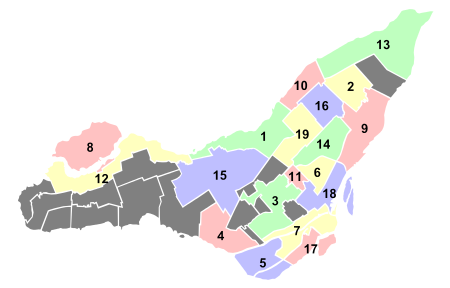
List of Montreal boroughs[edit]

| Number (map) |
Borough | Population Canada 2016 Census[1] |
Area in km² |
Density per km² |
|---|---|---|---|---|
| 1. | Ahuntsic-Cartierville | 134,245 |
24.2 |
5,547.3
|
| 2. | Anjou | 42,796 |
13.7 |
3,123.8
|
| 3. | Côte-des-Neiges–Notre-Dame-de-Grâce | 166,520 |
21.4 |
7,781.3
|
| 4. | Lachine | 44,489 |
17.7 |
2,513.5
|
| 5. | LaSalle | 76,853 |
16.3 |
4,714.9
|
| 6. | Le Plateau-Mont-Royal | 104,000 |
8.1 |
12,839.5
|
| 7. | Le Sud-Ouest | 78,151 |
15.7 |
4,977.8
|
| 8. | L'Île-Bizard–Sainte-Geneviève | 18,413 |
23.6 |
780.2
|
| 9. | Mercier–Hochelaga-Maisonneuve | 136,024 |
25.4 |
5,355.3
|
| 10. | Montréal-Nord | 84,234 |
11.1 |
7,588.6
|
| 11. | Outremont | 23,954 |
3.9 |
6,142.0
|
| 12. | Pierrefonds-Roxboro | 69,297 |
27.1 |
2,557.1
|
| 13. | Rivière-des-Prairies–Pointe-aux-Trembles | 106,734 |
42.3 |
2,523.2
|
| 14. | Rosemont–La Petite-Patrie | 139,590 |
15.9 |
8,779.2
|
| 15. | Saint-Laurent | 98,828 |
42.8 |
2,309.1
|
| 16. | Saint-Léonard | 78,305 |
13.5 |
5,800.4
|
| 17. | Verdun | 69,229 |
9.7 |
7,137.0
|
| 18. | Ville-Marie | 89,170 |
16.5 |
5,404.2
|
| 19. | Villeray–Saint-Michel–Parc-Extension | 143,853 |
16.5 |
8,718.3
|
List of former boroughs[edit]
Map[edit]


See also[edit]
References[edit]
- ^ "Population totale en 2011 et en 2016 - Variation — Densité" (PDF). Canada 2016 Census (in French). Ville de Montréal. 2016. Retrieved 1 December 2018.
