About The Project
A proposed oil pipeline from Alberta to Nebraska
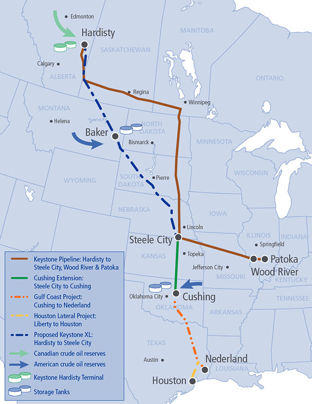
Download the Keystone XL overall route map (PDF, 437 KB)
The Keystone XL Pipeline Project is a proposed 1,179-mile (1,897 km), 36-inch-diameter crude oil pipeline, beginning in Hardisty, Alta., and extending south to Steele City, Neb. This pipeline is a critical infrastructure project for the energy security of the United States and for strengthening the American economy.
Along with transporting crude oil from Canada, the Keystone XL Pipeline will also support the significant growth of crude oil production in the United States from producers in the Bakken region of Montana and North Dakota.
This pipeline will allow Canadian and American oil producers more access to the large refining markets found in the American Midwest and along the U.S. Gulf Coast.
In May, 2012, TransCanada filed a new application for a Presidential Permit with the U.S. Department of State, a requirement for building any cross-border pipeline. TransCanada also chose to proceed with the southern portion of its Keystone expansion as a separate project, the Gulf Coast Pipeline Project.
In January, 2013, Governor Dave Heineman approved TransCanada’s proposed route in Nebraska. The revised route will minimize disturbance of land, water resources and special areas in the state.
On March 1, 2013, the U.S. Department of State released a Draft Supplementary Environmental Impact Statement (Draft SEIS) on Keystone XL that reaffirmed “there would be no significant impacts to most resources along the proposed Project route.”
With an anticipated decision on the Presidential Permit in 2013, the Keystone XL Pipeline has a projected in-service date of 2015.
The pipeline will have capacity to transport 830,000 barrels of oil per day to Gulf Coast and Midwest refineries, reducing American dependence on oil from Venezuela and the Middle East by up to 40 per cent.
Quick facts
Keystone XL
- 329 miles (529 km) in Canada (Hardisty, Alta., to Monchy, Sask.)
- 850 miles (1,368 km) in the United States (Phillips County, Mont. to Steele City, Neb.)
- 36-inch diameter pipeline
- Capacity of 830,000 barrels per day
- Anticipated cost of US$5.3 billion
- Projected in-service date of 2015
Route Maps


