Wildfire Smoke and Air Quality
Smoke from forest fires or grass fires is one of the most serious air quality problems for Canadians. All provinces and territories can be affected. The Government of Canada has several products to help Canadians protect themselves from wildfire smoke:
Be alert for wildfire smoke
Air quality alerts
If your community is at immediate risk from air pollution caused by dense wildfire smoke, Environment and Climate Change Canada will issue an air quality alert.
Smoke predictions
Environment and Climate Change Canada issues twice-daily smoke predictions (FireWork) that show where smoke from fires in Canada and the United States is expected to spread over the next 48 hours (available April 1 to October 31 only). FireWork does not predict the burn path of a wildfire.
- Evening forecast: a computer-generated smoke animation that indicates how wildfire smoke is expected to spread hour by hour, for the next 48 hours (starting at 00:00 UTC* and updated at 05:30 UTC). One-hour steps in the animation can be viewed separately.
- Morning forecast: a computer-generated smoke animation that indicates how wildfire smoke is expected to spread hour by hour, for the next 48 hours (starting at 12:00 UTC * and updated at 17:00 UTC). One-hour steps in the animation can be viewed separately.
Air Quality Health Index forecasts
Find out about the level of air pollution in your community year-round by checking the Air Quality Health Index (AQHI). The AQHI forecasts and current values will reflect the impacts that wildfire smoke may have on human health. AQHI forecasts are issued twice a day and current conditions are updated hourly.
Wildfire locations
Information on the location of current wildfires and on wildfire risks in different parts of the country can be found at Natural Resources Canada’s Canadian Wildfire Information System.
Approaching wildfires
If you are in an area that is threatened by an approaching wildfire, you should be developing a plan to protect yourself, including being prepared to leave the area at short notice. Find out what to do in a wildfire emergency.
Wildfire smoke and your health
Watch for these symptoms:
Keep alert for the milder effects of smoke exposure:
- sore and watery eyes
- runny nose and sinus irritation
- scratchy throat and coughing
- headache
The more serious consequences include:
- breathing difficulties, including asthma attacks.
- chest pains
- heart palpitations
- heart attacks
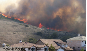
During the wildfire season (April to October), fire can sweep through Canada’s forests and grasslands, producing dense smoke that can be a major source of toxic air pollutants. Fine particles in the smoke can penetrate deep into the lungs and can lead to serious health effects, particularly for small children, pregnant women, the elderly, and those with lung and heart conditions. Anyone involved in strenuous outdoor work or sports is also at greater risk. During heavy smoke conditions, everyone is at risk.
Because smoke can be carried by high level winds, locations hundreds and even thousands of kilometres, communities downwind can be almost as severely affected as those close to the fire zone. Dense smoke from wildfires can cause very high levels of air pollution, with the amount of fine particles in the air greatly exceeding normal levels.
Protecting your health from wildfire smoke
There are many actions you can take to protect yourself from wildfire smoke. Those at higher risk should begin to take precautions before the smoke becomes heavy:
- Limit outdoor activity and strenuous physical activities as much as possible. If you have difficulty breathing, reduce your activities or stop altogether.
- At home: stay indoors with the windows closed. Turn off your furnace and air conditioner as it may draw smoke indoors. Keep indoor air cleaner by avoiding smoking or burning other materials.
- In a vehicle: keep the windows closed and set the ventilation system to recirculate.
- Care for others: Watch out for others in your care who may be more vulnerable to smoke.
- Leave the area: If you are able to, make arrangements to move to a location with cleaner air.
- Consult your physician or local health authority for additional advice. Most provinces and territories also offer health advice through a telephone hotline.
Wildfire Smoke and Weather
In Canada, over 8,000 wildfires occur each year, and about 2 million hectares are burned, according to data from the National Forestry Database. About half these fires are ignited by lightning strikes, with the remainder being caused by human activities.
Weather is a critical factor that affects whether a fire will start, how it will behave after it starts, and how the smoke will spread.
Dry conditions are a key factor in increasing the risk of wildfire. In a prolonged dry spell, trees, ground litter and other fuel dries out and ignites more readily. A low snow pack in winter, as well as a lack of rainfall in spring and summer, will increase the chances of dryness. High temperatures will increase evaporation, causing further moisture loss. Once the fire begins, the wind can play a major role. Strong winds feed the fire with oxygen, and cause it to grow and spread. The wind also influences the direction in which the fire travels.
Weather also determines how the smoke will spread and where it will be carried by the wind. Conditions in the atmosphere determine whether the smoke will remain near the ground, or whether it will be carried aloft. If a cool, dense layer of air forms near the ground, and the winds are light, a temperature inversion can trap the smoke near the surface. The smoke will then remain within the local area and can lead to severe air pollution at ground level.
However, often the air near the ground is warmer than the air above, and the smoke will rise. Strong, turbulent winds can disperse the smoke. If there is little or no wind, the smoke plume can remain relatively intact and rise to considerable heights, where it can be carried hundreds and even thousands of kilometres from the fire zone. During the summer of 2015, for example, smoke from major forest fires in Western Canada moved through Ontario and Québec, and reached as far east as the Atlantic provinces. This phenomenon is known as long-range transport.
Smoke that is moving across the country can remain at a high level in the atmosphere, or, with changes in weather conditions, can suddenly move down to ground level, where it can cause severe local air pollution, even very long distances from the source of the fire.
View animations on air quality and weather.
FireWork: Canada’s Wildfire Smoke Prediction System
The health impacts of smoke pollution can be greatly reduced if people know that wildfire smoke is coming and can take precautions to reduce their exposure. To help Canadians anticipate wildfire smoke events, Environment and Climate Change Canada has developed FireWork, a smoke prediction system that operates during the wildfire season and makes it possible to include wildfire smoke in air quality forecasts.
One of FireWork’s most useful features is the ability to produce images and animated maps that show the location of wildfire smoke and predicts its effect on local air quality. The maps indicate how the smoke is expected to spread hour by hour over the next 48 hours and the amount of fine particles that it will add to the air. You can use these maps to see how your community may be affected by wildfire smoke.
On the maps, the thickness of the smoke is indicated by color, based on the expected amount of fine particles in the air. As the smoke thickens, the smell gets stronger and visibility is reduced. The red and black areas on the maps (between 200 and 500+ micrograms of PM2.5 per cubic metre) indicate where the smoke is the heaviest, and the amount of fine particles is the greatest. This indicates a very severe level of air pollution – comparable to the highest levels of smog recorded in the world’s largest cities. This would be 50 times more than the World Health Organization’s guideline for safe exposure to fine particles (24-hour average concentrations of PM2.5).

Map from Canada's Wildfire Smoke Prediction System (FireWork) showing the forecast for July 29, 2015 with smoke spreading across the country from fires in Western Canada.
- Date modified: