Phenomena
Contents
Tides and Tidal Streams
In a tide wave the horizontal motion, i.e. the particle velocity, is called the tidal stream. The vertical tide is said to rise and fall, and the tidal stream is said to flood and ebb. If the tide is progressive, the flood direction is that of the wave propagation: if the tide is a standing wave, the flood direction is inland or toward the coast, i.e. «upstream.» The flow is the net horizontal motion of the water at a given time from whatever causes. The single word «current» is frequently used synonymously with «flow», but the term residual current is used for the portion of the flow not accounted for by the tidal streams. A tidal stream is rectilinear if it flows back and forth in a straight line, and is rotary if its velocity vector traces out an ellipse. Except in restricted coastal passages, most tidal streams are rotary, although the shape of the ellipse and the direction of rotation may vary. The ellipse traced out by a tidal stream vector is called the tidal ellipse. Slack water refers to zero flow in a tidal regime. The stand of the tide is the interval around high or low water in which there is little change of water level: this need not coincide with slack water.
Since the observed tide consists not of a single wave, but of the superposition of many tide waves of different frequency and amplitude, it will never fit exactly any of our simple descriptions. Because of this, we cannot expect the heights of successive High Waters (HWs) or of successive Low Waters (LWs) to be identical, even when they occur in the same day. Thus, the two HWs and two LWs occurring in the same day are designated as higher and lower high water (HHW and LHW), and higher and lower low water (HLW and LLW). It is likewise only the tidal stream associated with a single frequency tide wave that traces a perfect tidal ellipse. The composite tidal stream each day traces a path more closely resembling a double spiral, with no two days patterns identical. Also, no tide is ever a purely progressive or a purely standing wave, so that slack water should not be expected to occur at the same interval before HW or LW at all locations. Canadian Tidal Manual
Shallow-Water Effects
Generality
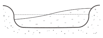
Tides in the open ocean are usually of much smaller amplitude than those along the coast. This is partly due to amplification by reflection and resonance. It is, however, more generally the result of shoaling: as the wave propagates into shallower water, its wave speed decreases and the energy contained between crests is compressed both into a smaller depth and a shorter wavelength. The tide height and the tidal stream strength must increase accordingly. If, in addition, the tide propagates into an inlet whose width diminishes toward the head, the wave energy is further compressed laterally. This effect, called funneling, also causes the tide height to increase. Canadian Tidal Manual
Tidal Bores
Sometimes the front of the rising tide propagates up a river as a bore, a churning and tumbling wall of water advancing up the river not unlike a breaking surf riding up a beach (Fig. 1).
Creation of a bore requires a large rise of tide at the mouth of the river, some sandbars, or other restrictions at the entrance to impede the initial advance of the tide, and a shallow and gently sloping river bed. Simply stated, the water cannot spread uniformly over the vast shallow interior area fast enough to match the rapid rise at the entrance. Friction at the base of the advancing front, plus resistance from the last of the ebb flow still leaving the river, causes the top of the advancing front to tumble forward, sometimes giving the bore the appearance of a travelling waterfall.
(Photo by D.G. Mitchell, Canadian Hydrographic Service, 1960)
(Photo by F.G. Barber, Ocean Science and Surveys, DFO, 1982)
There are spectacular bores a meter or more high in several rivers and estuaries of the world. The best known bore in Canada is that in the Petitcodiac River near Moncton, N.B., but there is another in the Shubenacadie River and in the Salmon River near Truro, N.S., all driven by the large Bay of Fundy tides. These are impressive (about a meter) only at the time of the highest monthly tides, and may be no more than a large ripple during the smallest tides. Canadian Tidal Manual
Reversing Falls
The reversing falls near the mouth of the St. John River at Saint John, N.B. is also caused by the large Bay of Fundy tides and the configuration of the river. A narrow gorge at Saint John separates the outer harbour from a large inner basin. When the tide is rising most rapidly outside, water cannot pass quickly enough through the gorge to raise the level of the inner basin at the same rate, so on this stage of the tide the water races in through the gorge, dropping several meters over the length of the gorge. When the outside tide is falling most rapidly, the situation is reversed, and the water races out through the gorge in the opposite direction, again dropping several meters in surface elevation. Twice during each tidal cycle, when the water levels inside and out are the same, the water in the gorge is placid and navigable. The surface of the water in the gorge near the peak flows is violently agitated and the velocity of flow is too rapid and turbulent to permit navigation through the gorge. Canadian Tidal Manual
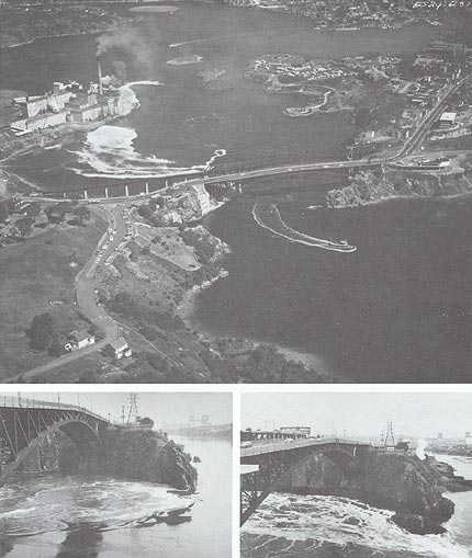
(Upper photo by Lockwood Survey, NFB Phototeque, 1966; Lower photos by D.G. Mitchell, Canadian Hydrographic Service, 1963.)
The upper photo is an aerial view at slack water, showing the inner basin, the outer harbour, and the bridge over that separates them. Lower left shows the inflow through the gorge at high water in the outer harbour (7.6 m above chart datum at time of photo). Lower right shows the outflow though the gorge at low water in the outer harbour (0.9 m above hart datum at time of photo). The recorded extreme high and low waters at Saint John are 9.0 and -0.4 m,. respectively, above chart datum, and at these times the flows would have been correspondingly greater. Canadian Tidal Manual
Tide Rip (Overfall)
A tide rip or overfall is an area of breaking waves or violent surface agitation that may occur at certain stages of the tide in the presence of strong tidal flow. They may be caused by a rapid flow over an irregular bottom, by the conjunction of two opposing flows, or by the piling up of waves or swell against an oppositely directed tidal flow. If waves run up against a current, the wave form and the wave energy are compressed into a shorter wavelength, causing a growth and steepening of the waves. If the current is strong enough, the waves may steepen to the point of breaking, and dissipate their energy in a wild fury at sea. Canadian Tidal Manual
Non-Tidal Influences
Wind-driven currents, and Atmospheric pressure effects (Storm surges)
Because the tide usually dominates the spectrum of water level and current fluctuations along the ocean coasts, it is common to think of non-tidal fluctuations mostly in connection with inland waters. The tide in the deep ocean, however, can be quite insignificant and the tidal streams completely negligible from the standpoint of navigation. Wind-driven surface currents in the deep ocean, on the other hand, are of major importance to navigation. Water levels along ocean coasts are just as surely affected by atmospheric pressure and wind as are water levels along the shores of inland bodies of water.
This is the case of storm surge. As the name suggests, storm surges are pronounced increases in water level associated with the passage of storms. Much of the increase is the direct result of wind set-up and the inverted barometer effect under the low pressure area near the center of the storm. There is, however, another process by which the surge may become more exaggerated than would be anticipated from these two effects alone. As the storm depression travels over the water surface, a long surface wave travels along with it. If the storm path is such as to direct this wave up on shore, the wave may steepen and grow as a result of shoaling and tunneling, (see Shallow-water effects). The term «negative surge» is sometimes used to describe a pronounced non-tidal decrease in water level. These could be associated with offshore winds and travelling high pressure systems, and are not usually as extreme as storm surges. Negative surges may, however, be of considerable concern to mariners, since they can create unusually shallow water if they occur near the low tide stage.
The range, however, is generally small compared to that of the tide on the coast, and the importance may not be fully realized until an extreme of the non-tidal fluctuations coincides with a corresponding extreme (high or low) of the tidal fluctuation. In using tidal predictions, such as those in the Canadian Tide and Current Tables, it should be borne in mind that they contain no allowance for non-tidal effects, other than for the average seasonal change in mean water leve. Canadian Tidal Manual
Seiches
A seiche is the free oscillation of the water in a closed or semi-enclosed basin at its natural period. Seiches are frequently observed in harbours, lakes, bays. And in almost any distinct basin of moderate size. They may be caused by the passage of a pressure system over the basin or by the build-up and subsequent relaxation of a wind set-up in the basin. Following initiation of the seiche, the water sloshes back and forth until the oscillation is damped out by friction.
Seiches are not apparent in the main ocean basins, probably because there is no force sufficiently coordinated over the ocean to set a seiche in motion. The tides are not seiches, being forced oscillations at tidal frequencies. If the natural period, or seiche period, is close to the period of one of the tidal species, the constituents of that species (diurnal or semidiurnal) will be amplified by resonance more than those of other species. The constituent closest to the seiche period will be amplified most of all, but the response is still a forced oscillation, whereas a seiche is a free oscillation. A variety of seiche periods may appear in the same water level record because the main body of water may oscillate longitudinally or laterally at different periods, it may also oscillate both in the open and closed mode if the open end is somewhat restricted, and bays and harbours off the main body of water may oscillate locally at their particular seiche periods. Seiches generally have half-lives of only a few periods, but may be frequently regenerated. The largest amplitude seiches are usually found in shallow bodies of water of large horizontal extent, probably because the initiating wind set-up can be greater under these conditions. Canadian Tidal Manual
Tsunamis
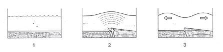
A tsunami is a disturbance of the water surface caused by a displacement of the sea-bed or an underwater landslide, usually triggered by an earthquake or an underwater volcanic eruption. The surface disturbance travels out from the center of origin in much the same pattern as do the ripples from the spot where a pebble lands in a pond. In some directions the waves may almost immediately dissipate their energy against a nearby shore, while in other directions they may be free to travel for thousands of kilometers across the ocean as a train of several tens of long wave crests. Being long waves, they travel at the speed (gD)½, giving them a speed of over 700 km/h (almost 400 knots) when travelling in a depth of 4 000 m. The period between crests may vary from a few minutes to the order of 1 h, so that in a depth of 4 000 m the distance between crests might range from less than a hundred to several hundred kilometers.
The wave heights at sea are only the order of a metre, and over a wavelength of several hundred kilometers this does not constitute a significant distortion of the sea surface. When these waves arrive in shallow water, however, their energy is concentrated by shoaling and possibly tunneling, causing them to steepen and rise to many meters in height. Not only are the tsunami waves high, but they are also massive when they arrive on shore, and are capable of tremendous destruction in populated areas. Because of the relative gentleness of tsunamis in deeper water, ships should always leave harbour and head for deep offshore safety when warned of an approaching tsunami.
(Photo of "Oceanography of the British Columbia coast" Richard E. Thomson, DFO, Ottawa, 1984)
The origin of the word is, in fact, from the Japanese expression for «harbour wave.» This name has been adopted to replace the popular expression «tidal wave,» whose use is to be discouraged since there is nothing tidal in the origin of a tsunami. Another expression sometimes used for these waves is «seismic sea wave,» suggesting the seismic, or earthquake, origin of most tsunamis.
A tsunami warning system for the Pacific has been established by the United States, with its headquarters in Honolulu, Hawaii. Other countries, including Canada, that border on the Pacific have since been recruited into the system. Canada's direct contribution consists of two automatic water level gauges programmed to recognize unusual water level changes that could indicate the passage of a tsunami, and to transmit this advice to Honolulu. The gauges are at Tofino on the west coast of Vancouver Island, and at Langara Island off the northwest tip of the Queen Charlotte Islands group. The tsunami warning center at Honolulu receives immediate information from seismic recording stations around the Pacific of any earthquake that could possibly generate a tsunami; it calculates the epicenter and intensity of the quake and the arrival time of the as yet hypothetical tsunami at the water level sensing stations in the network; it initiates a «tsunami watch» at all water level stations in the path, for a generous time interval around the ETA of the hypothetical tsunami; and it issues tsunami warnings to the appropriate authorities in threatened locations if the water level interpretation indicates that a tsunami has indeed been generate. Canadian Tidal Manual
Melting and freezing
When seawater freezes, it is only the water that forms into ice crystals. The salt becomes trapped between the crystals in a concentrated brine that eventually leaches out, leaving mostly pure ice floating on the surface, surrounded by sea water of increased salinity and density. Since the ice displaces its own weight in this denser water, it does not displace as much volume as it occupied before freezing. Because of this, freezing has an effect similar to that of evaporation - it lowers the water level and increases the surface salinity and density. Surface water must therefore flow toward a region of freezing, while the cold salty water that is formed must sink and flow away from the region. In the polar regions, particularly in the Antarctic, freezing produces cold salty water that sinks and flows along the ocean bottom for thousands of kilometers. When sea ice melts, mostly fresh water is released, and this decreases the salinity and the density of the surrounding water. Melting thus has an effect similar to that of precipitation - it raises the water level and decreases the surface salinity and density. Surface water must therefore flow away from a region of melting ice. The speed of currents associated with freezing and melting in the ocean are never great. Canadian Tidal Manual