Portal:Geography
The Geography Portal

Geography (from Greek: γεωγραφία, geographia, literally "earth description") is a field of science devoted to the study of the lands, features, inhabitants, and phenomena of the Earth and planets. The first person to use the word γεωγραφία was Eratosthenes (276–194 BC). Geography is an all-encompassing discipline that seeks an understanding of Earth and its human and natural complexities—not merely where objects are, but also how they have changed and come to be.
Geography is often defined in terms of two branches: human geography and physical geography. Human geography is concerned with the study of people and their communities, cultures, economies, and interactions with the environment by studying their relations with and across space and place. Physical geography is concerned with the study of processes and patterns in the natural environment like the atmosphere, hydrosphere, biosphere, and geosphere.
The four historical traditions in geographical research are spatial analyses of natural and the human phenomena, area studies of places and regions, studies of human-land relationships, and the Earth sciences. Geography has been called "the world discipline" and "the bridge between the human and the physical sciences". (Full article...)
 Featured article -

 St. Johns River near Astor
The St. Johns River (Spanish: Río San Juan) is the longest river in the U.S. state of Florida and its most significant one for commercial and recreational use. At 310 miles (500 km) long, it flows north and winds through or borders twelve counties. The drop in elevation from headwaters to mouth is less than 30 feet (9 m); like most Florida waterways, the St. Johns has a very low flow rate 0.3 mph (0.13 m/s) and is often described as "lazy".
Numerous lakes are formed by the river or flow into it, but as a river its widest point is nearly 3 miles (5 km) across. The narrowest point is in the headwaters, an unnavigable marsh in Indian River County. The St. Johns drainage basin of 8,840 square miles (22,900 km2) includes some of Florida's major wetlands. It is separated into three major basins and two associated watersheds for Lake George and the Ocklawaha River, all managed by the St. Johns River Water Management District. (Full article...)
The Chalukya dynasty ([tʃaːɭukjə]) was a Classical Indian dynasty that ruled large parts of southern and central India between the 6th and the 12th centuries. During this period, they ruled as three related yet individual dynasties. The earliest dynasty, known as the "Badami Chalukyas", ruled from Vatapi (modern Badami) from the middle of the 6th century. The Badami Chalukyas began to assert their independence at the decline of the Kadamba kingdom of Banavasi and rapidly rose to prominence during the reign of Pulakeshin II. After the death of Pulakeshin II, the Eastern Chalukyas became an independent kingdom in the eastern Deccan. They ruled from Vengi until about the 11th century. In the western Deccan, the rise of the Rashtrakutas in the middle of the 8th century eclipsed the Chalukyas of Badami before being revived by their descendants, the Western Chalukyas, in the late 10th century. These Western Chalukyas ruled from Kalyani (modern Basavakalyan) until the end of the 12th century.
The rule of the Chalukyas marks an important milestone in the history of South India and a golden age in the history of Karnataka. The political atmosphere in South India shifted from smaller kingdoms to large empires with the ascendancy of Badami Chalukyas. A Southern India-based kingdom took control and consolidated the entire region between the Kaveri and the Narmada rivers. The rise of this empire saw the birth of efficient administration, overseas trade and commerce and the development of new style of architecture called "Chalukyan architecture". Kannada literature, which had enjoyed royal support in the 9th century Rashtrakuta court found eager patronage from the Western Chalukyas in the Jain and Veerashaiva traditions. The 11th century saw the patronage of Telugu literature under the Eastern Chalukyas. (Full article...)
Laguna del Maule is a volcanic field in the Andes mountain range of Chile, close to, and partly overlapping, the Argentina–Chile border. The bulk of the volcanic field is in the Talca Province of Chile's Maule Region. It is a segment of the Southern Volcanic Zone, part of the Andean Volcanic Belt. The volcanic field covers an area of 500 km2 (190 sq mi) and features at least 130 volcanic vents. Volcanic activity has generated cones, lava domes, lava coulees and lava flows, which surround the Laguna del Maule lake. The field gets its name from the lake, which is also the source of the Maule River.
The field's volcanic activity began 1.5 million years ago during the Pleistocene era; such activity has continued into the postglacial and Holocene era after glaciers retreated from the area. Postglacial volcanic activity has included eruptions with simultaneous explosive and effusive components, as well as eruptions with only one component. In the postglacial era, volcanic activity has increased at Laguna del Maule, with the volcanic field rapidly inflating during the Holocene. Three major caldera-forming eruptions took place in the volcanic field prior to the last glacial period. The most recent eruptions in the volcanic field took place 2,500 ± 700, 1,400 ± 600 and 800 ± 600 years ago and generated lava flows; today geothermal phenomena occur at Laguna del Maule. Volcanic rocks in the field include basalt, andesite, dacite and rhyolite; the latter along with rhyodacite makes up most of the Holocene rocks. In pre-Columbian times, the field was a regionally important source of obsidian. (Full article...)
Barry Voight (/vɔɪt/; born 1937) is an American geologist, volcanologist, author, and engineer. After earning his Ph.D. at Columbia University, Voight worked as a professor of geology at several universities, including Pennsylvania State University, where he taught from 1964 until his retirement in 2005. He remains an emeritus professor there and still conducts research, focusing on rock mechanics, plate tectonics, disaster prevention, and geotechnical engineering.
In April 1980, Voight's publications on landslides, avalanches, and other mass movements attracted the attention of Rocky Crandell of the United States Geological Survey (USGS), who asked him to look at a growing bulge on the Mount St. Helens volcano in the state of Washington. Voight foresaw the collapse of the mountain's north flank as well as a powerful eruption. His predictions came true when St. Helens erupted in May 1980; Voight was then hired by the USGS to investigate the debris avalanche that initiated the eruption. After his work at Mount St. Helens brought him international recognition, Voight continued researching and guiding monitoring efforts at several active volcanoes throughout his career, including Nevado del Ruiz in Colombia, Mount Merapi in Indonesia, and Soufrière Hills, a volcano on the Caribbean island of Montserrat. For his research, publications, and disaster prevention work as a volcanologist and engineer, Voight has been honored with numerous awards, appointments, and medals. (Full article...)
Upper Pine Bottom State Park is a 5-acre (2.0 ha) Pennsylvania state park in Lycoming County, Pennsylvania in the United States. The park is in Cummings Township on Pennsylvania Route 44 and is surrounded by the Tiadaghton State Forest. It is on Upper Pine Bottom Run, which gave the park its name and is a tributary of Pine Creek. Upper Pine Bottom State Park is in the Pine Creek Gorge, where the streams have cut through five major rock formations from the Devonian and Carboniferous periods.
The earliest recorded inhabitants of the area were the Susquehannocks, followed by the Iroquois, Lenape, and Shawnee. Upper Pine Bottom Run was the site of a furnace for pig iron in 1814, the first sawmill was built on it in 1815, and in 1825 an earlier bridle path across its headwaters became a turnpike. The lumber industry led to the clearcutting of the area in the 19th century. The state forest was started in 1898 and the park was formed from it by 1923 as a Class B public camp. The Civilian Conservation Corps had a camp on the run and improved the park in the 1930s, but it was not transferred to the Bureau of State Parks until 1962. Though it began as a public campsite and once had a picnic pavilion, as of 2022 it is for day use only and its only facilities are a few picnic tables and a parking area. (Full article...)
On 15 March 1921, Armenian student Soghomon Tehlirian assassinated Talaat Pasha—former grand vizier of the Ottoman Empire and the main architect of the Armenian genocide—in Berlin. At his trial, Tehlirian argued, "I have killed a man, but I am not a murderer", and the jury acquitted him.
Tehlirian came from Erzindjan in the Ottoman Empire but moved to Serbia before the war; he served in the Armenian volunteer units of the Russian army and lost most of his family in the genocide. Deciding to take revenge, he assassinated Harutian Mgrditichian, who helped the Ottoman secret police, in Constantinople. Tehlirian joined Operation Nemesis, a clandestine program carried out by the Dashnaktsutyun (the Armenian Revolutionary Federation), and was chosen for the mission to assassinate Talat due to his previous success. Talat had already been convicted and sentenced to death by an Ottoman court-martial, but was living in Berlin with the permission of the German government. Many prominent Germans attended Talat's funeral, and the German Foreign Office sent a wreath saying, "To a great statesman and a faithful friend." (Full article...)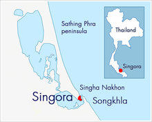 The Sultanate of Singora was a heavily fortified port city in the deep south of Thailand.
The Sultanate of Singora was a heavily fortified port city in southern Thailand and the precursor of the present-day town of Songkhla. It was founded in the early 17th century by a Persian, Dato Mogol, and flourished during the reign of his son, Sultan Sulaiman Shah. In 1680, after decades of conflict, the city was destroyed and abandoned; remains include forts, city walls, a Dutch cemetery and the tomb of Sultan Sulaiman Shah. An inscribed cannon from Singora bearing the seal of Sultan Sulaiman Shah is displayed next to the flagpole at the Royal Hospital Chelsea, London.
The sultanate's history was documented in accounts, letters and journals written by British and Dutch East India Company traders; its destruction was discussed in books and reports authored by representatives of the French embassies to Siam in the mid 1680s. Sultan Sulaiman's family history has also been chronicled: Princess Sri Sulalai, a consort of King Rama II and mother of King Rama III, was descended from Sultan Sulaiman; present-day descendants include the 22nd Prime Minister of Thailand and a former Navy admiral. Sources pertaining to the Singora cannon include articles published in academic journals and letters written by General Sir Harry Prendergast, commander of the Burma Expeditionary Force that captured Mandalay in the third Anglo-Burmese War. (Full article...)
Bryce Canyon National Park (/braɪs/) is an American national park located in southwestern Utah. The major feature of the park is Bryce Canyon, which despite its name, is not a canyon, but a collection of giant natural amphitheaters along the eastern side of the Paunsaugunt Plateau. Bryce is distinctive due to geological structures called hoodoos, formed by frost weathering and stream erosion of the river and lake bed sedimentary rocks. The red, orange, and white colors of the rocks provide spectacular views for park visitors. Bryce Canyon National Park is much smaller and sits at a much higher elevation than nearby Zion National Park. The rim at Bryce varies from 8,000 to 9,000 feet (2,400 to 2,700 m).
The Bryce Canyon area was settled by Mormon pioneers in the 1850s and was named after Ebenezer Bryce, who homesteaded in the area in 1874. The area around Bryce Canyon was originally designated as a national monument by President Warren G. Harding in 1923 and was redesignated as a national park by Congress in 1928. The park covers 35,835 acres (55.992 sq mi; 14,502 ha; 145.02 km2) and receives substantially fewer visitors than Zion National Park (nearly 4.3 million in 2016) or Grand Canyon National Park (nearly 6 million in 2016), largely due to Bryce's more remote location. In 2018, Bryce Canyon received 2,679,478 recreational visitors, which was an increase of 107,794 visitors from the prior year. (Full article...)
Boston (US: /ˈbɔːstən/, UK: /ˈbɒstən/), officially the City of Boston, is the capital and most populous city of the Commonwealth of Massachusetts in the United States and 24th-most populous city in the country. The city proper covers 48.4 square miles (125 km2) with a population of 675,647 in 2020, also making it the most populous city in New England. It is the seat of Suffolk County (although the county government was disbanded on July 1, 1999). The city is the economic and cultural anchor of a substantially larger metropolitan area known as Greater Boston, a metropolitan statistical area (MSA) home to a census-estimated 4.8 million people in 2016 and ranking as the tenth-largest MSA in the country. A broader combined statistical area (CSA), generally corresponding to the commuting area and including Providence, Rhode Island, is home to some 8.2 million people, making it the sixth most populous in the United States.
Boston is one of the oldest municipalities in the United States, founded on the Shawmut Peninsula in 1630 by Puritan settlers from the English town of the same name. It was the scene of several key events of the American Revolution, such as the Boston Massacre, the Boston Tea Party, the Battle of Bunker Hill and the siege of Boston. Upon American independence from Great Britain, the city continued to be an important port and manufacturing hub as well as a center for education and culture. The city has expanded beyond the original peninsula through land reclamation and municipal annexation. Its rich history attracts many tourists, with Faneuil Hall alone drawing more than 20 million visitors per year. Boston's many firsts include the United States' first public park (Boston Common, 1634), first public or state school (Boston Latin School, 1635) and first subway system (Tremont Street subway, 1897). (Full article...)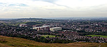 A view of Shaw and Crompton from Crompton Moor
Shaw and Crompton is a civil parish in the Metropolitan Borough of Oldham, Greater Manchester, England, which contains the town of Shaw and lies on the River Beal at the foothills of the South Pennines. It is located 2.3 miles (3.7 km) north of Oldham, 3.6 miles (5.8 km) south-east of Rochdale and 8.7 miles (14 km) north-east of Manchester.
Historically in Lancashire, the area shows evidence of ancient British and Anglian activity. In the Middle Ages, Crompton formed a small township of scattered woods, farmsteads, moorland and swamp. The local lordship was weak or absent, and so Crompton failed to emerge as a manor with its own lord and court. Farming was the main industry of this rural area, with locals supplementing their incomes by hand-loom woollen weaving in the domestic system. (Full article...)
The Sloan–Parker House, also known as the Stone House, Parker Family Residence, or Richard Sloan House, is a late-18th-century stone residence near Junction, Hampshire County, in the U.S. state of West Virginia. It was built on land vacated by the Shawnee after the Native American nation had been violently forced to move west to Kansas following their defeat at the Battle of Point Pleasant in 1774. The building was added to the National Register of Historic Places on June 5, 1975, becoming Hampshire County's first property to be listed on the register. The Sloan–Parker House has been in the Parker family since 1854. The house and its adjacent farm are located along the Northwestern Turnpike (US 50/WV 28) in the rural Mill Creek valley.
The original fieldstone section of the house was erected in about 1790 for Richard Sloan and his wife Charlotte Van Horn Sloan. Originally from Ireland, Sloan arrived in the United States after the American Revolutionary War and became an indentured servant of David Van Horn. Sloan eloped with Van Horn's daughter Charlotte and they settled in the Mill Creek valley, where they built the original stone portion of the house. The Sloans had ten children, including John and Thomas Sloan, who each (later) represented Hampshire County in the Virginia House of Delegates. Richard Sloan and his family operated a successful weaving business from the stone house and their Sloan counterpanes (woven coverlets with block designs) became well known in the South Branch Valley region. (Full article...)
The Trout Creek Mountains are a remote, semi-arid Great Basin mountain range mostly in southeastern Oregon and partially in northern Nevada in the United States. The range's highest point is Orevada View Benchmark, 8,506 feet (2,593 m) above sea level, in Nevada. Disaster Peak, elevation 7,781 feet (2,372 m), is another prominent summit in the Nevada portion of the mountains.
The mountains are characteristic of the Great Basin's topography of mostly parallel mountain ranges alternating with flat valleys. Oriented generally north to south, the Trout Creek Mountains consist primarily of fault blocks of basalt, which came from an ancient volcano and other vents, on top of older metamorphic rocks. The southern end of the range, however, features many granitic outcrops. As a whole, the faulted terrain is dominated by rolling hills and ridges cut by escarpments and canyons. (Full article...)
Chartwell is a country house near Westerham, Kent, in South East England. For over forty years it was the home of Winston Churchill. He bought the property in September 1922 and lived there until shortly before his death in January 1965. In the 1930s, when Churchill was out of political office, Chartwell became the centre of his world. At his dining table, he gathered those who could assist his campaign against German re-armament and the British government's response of appeasement; in his study, he composed speeches and wrote books; in his garden, he built walls, constructed lakes and painted. During the Second World War Chartwell was largely unused, the Churchills returning after he lost the 1945 election. In 1953, when again prime minister, the house became Churchill's refuge when he suffered a debilitating stroke. In October 1964, he left for the last time, dying at his London home, 28 Hyde Park Gate, on 24 January 1965.
The origins of the estate reach back to the 14th century; in 1382, the property then called Well-street was owned by William-at-Well. It passed through various owners and in 1836 was auctioned, as a substantial brick-built manor. In 1848, it was purchased by John Campbell Colquhoun, whose grandson sold it to Churchill. The Campbell Colquhouns greatly enlarged the house and the advertisement for its sale at the time of Churchill's purchase described it as an imposing mansion. Between 1922 and 1924, it was rebuilt and extended by the society architect Philip Tilden. From the garden front, the house has extensive views over the Weald of Kent, "the most beautiful and charming" Churchill had ever seen, and the determining factor in his decision to buy the house. (Full article...)
Frederick II (German: Friedrich II.; 24 January 1712 – 17 August 1786) was King in Prussia from 1740 until 1772, and King of Prussia from 1772 until his death. His most significant accomplishments include his military successes in the Silesian wars, his re-organisation of the Prussian Army, the First Partition of Poland, and his patronage of the arts and the Enlightenment. Frederick was the last Hohenzollern monarch titled King in Prussia and declared himself King of Prussia after annexing Polish Prussia from the Polish–Lithuanian Commonwealth in 1772. Prussia greatly increased its territories and became a major military power in Europe under his rule. He became known as Frederick the Great (German: Friedrich der Große) and was nicknamed "The Old Fritz" (German: "Der Alte Fritz").
In his youth, Frederick was more interested in music and philosophy than the art of war, which led to clashes with his authoritarian father, Frederick William I of Prussia. However, upon ascending to the Prussian throne, he attacked and annexed the rich Austrian province of Silesia in 1742, winning military acclaim for himself and Prussia. He then became an influential military theorist whose analysis emerged from his extensive personal battlefield experience and covered issues of strategy, tactics, mobility and logistics. (Full article...)
Alodia, also known as Alwa (Greek: Aρουα, Aroua; Arabic: علوة, ʿAlwa), was a medieval kingdom in what is now central and southern Sudan. Its capital was the city of Soba, located near modern-day Khartoum at the confluence of the Blue and White Nile rivers.
Founded sometime after the ancient kingdom of Kush fell, around 350 AD, Alodia is first mentioned in historical records in 569. It was the last of the three Nubian kingdoms to convert to Christianity in 580, following Nobadia and Makuria. It possibly reached its peak during the 9th–12th centuries when records show that it exceeded its northern neighbor, Makuria, with which it maintained close dynastic ties, in size, military power and economic prosperity. Being a large, multicultural state, Alodia was administered by a powerful king and provincial governors appointed by him. The capital Soba, described as a town of "extensive dwellings and churches full of gold and gardens", prospered as a trading hub. Goods arrived from Makuria, the Middle East, western Africa, India and even China. Literacy in both Nubian and Greek flourished. (Full article...)


.jpg)


.jpg)

In this month

- 1 January 2006 – University of Oklahoma College of Atmospheric and Geographic Sciences started, when it and the College of Earth and Energy were spun off of the old College of Geosciences
- 12 January 2001 – National Geographic Channel launched in the United States
- 25 January 1983 – Creation of the Instituto Nacional de Estadística y Geografía (pictured) in Mexico
- 27 January 1888 – Formation of the National Geographic Society
 Vital article
Asia (/ˈeɪʒə, ˈeɪʃə/ (
.svg)
Other vital articles
|
|---|
Related portals
Get involved
 |
Here are some tasks awaiting attention:
|
Selected pictures
 Map: Strebe, using GeocartThe Lambert conformal conic projection is a conic map projection used for aeronautical charts, portions of the State Plane Coordinate System, and many national and regional mapping systems. It is one of seven projections introduced by Johann Heinrich Lambert in 1772. Conceptually, the projection seats a cone over the sphere of the Earth and projects the surface conformally onto the cone. The cone is unrolled, and the parallel that was touching the sphere is assigned unit scale. By scaling the resulting map, two parallels can be assigned unit scale, with scale decreasing between them and increasing outside them. Unlike other conic projections, no true secant form of this projection exists.
 Map: Strebe, using GeocartThe Hobo–Dyer projection is a cylindrical equal-area projection commissioned in 2002 by Bob Abramms and Howard Bronstein. This projection was drafted by cartographer Mick Dyer, who based it on the 1910 Behrmann projection.
 Map: Strebe, using GeocartThe azimuthal equidistant projection is an azimuthal map projection in which all points on the map are both proportionately correct distances from the center point and at the correct azimuth (direction) from the center point. Distances and directions to all places, however, are true only from the center point of projection. This projection has been used for the flag of the United Nations, for the USGS National Atlas of the United States of America, and for large-scale mapping of Micronesia, among others.
 Image: Chris RywaltAn animation showing the unfolding of a Dymaxion map, a projection of a world map onto the surface of a polyhedron (in this case, an icosahedron) and then flattened to form a two-dimensional map which retains most of the relative proportional integrity of the globe map. This type of map was invented by Buckminster Fuller and is one of several of his inventions to use the name Dymaxion.
 Map: Strebe, using GeocartThe Peirce quincuncial projection is a conformal map projection developed by Charles Sanders Peirce in 1879, while he was working at the U.S. Coast and Geodetic Survey. In the normal aspect Peirce's projection presents the Northern Hemisphere in a square; the Southern Hemisphere is split into four 90°–45°–45° triangles surrounding it so that the whole map forms a larger square.
 Daedongyeojido is a large scale map of Korea produced by Chosun Dynasty cartographer and geologist Kim Jeong-ho in 1861. Considered to mark the zenith of pre-modern Korean cartography, the map consists of 22 separate, foldable booklets, each covering approximately 47 kilometres (29 mi) (north-south) by 31.5 kilometres (19.6 mi) (east-west). Combined, they form a map of Korea that is 6.7 metres (22 ft) wide and 3.8 metres (12 ft) long. Daedongyeojido is praised for precise delineations of mountain ridges, waterways, and transportation routes, as well as its markings for settlements, administrative areas, and cultural sites.
 Map: Strebe, using GeocartThe Tobler hyperelliptical projection is a family of equal-area pseudocylindrical map projections first described by Waldo R. Tobler in 1973. The imagery used for the map is derived from NASA's Blue Marble summer months composite, with oceans lightened to enhance legibility and contrast.
 Map credit: Robert WilkinsonAn 18th century map of the Iberian Peninsula illustrating various topographic features of the land. The Iberian Peninsula, or Iberia, is located in the extreme southwest of Europe, and includes modern day Spain, Portugal, Gibraltar and Andorra.
 The geography of Australia, the world's smallest continent, encompasses a wide variety of biogeographic regions. By surface area, it is the sixth-largest country in the world, but as can be seen in this composite satellite image, much of the interior is arid desert. The vast majority of the human population is concentrated along the eastern and southeastern coasts, and it is the fiftieth most populous nation.
 A world map entitled Nova totius terrarum orbis tabula Amstelodami, created in 1689 by Gerard van Schagen. This map, created in Amsterdam, measures 48.3 by 56.0 centimetres (19.0 by 22.0 in) in size and was made using copper engraving.
 Photo credit: NASAThe world's largest compass rose, drawn on the desert floor at Edwards Air Force Base in California, United States. Painted on the dry lake near Dryden Flight Research Center, it is inclined to magnetic north and is used by pilots for calibrating heading indicators.
 Map: Strebe, using GeocartThe sinusoidal projection is a pseudocylindrical equal-area map projection. Used as early as the 16th century, this projection shows distances accurately along the central meridian and the equator; areas furthest from these lines are the most distorted.
 Map credit: Heinrich C. BerannYellowstone National Park is an American national park located mostly in Wyoming and extending into Montana and Idaho. It was established by the U.S. Congress and signed into law by President Ulysses S. Grant on March 1, 1872. Yellowstone was the first national park in the U.S. and is also widely held to be the first national park in the world. The park is known for its wildlife and its many geothermal features, especially the Old Faithful geyser, one of its most popular landmarks. It has many types of ecosystems, but the subalpine forest is the most abundant. The park is part of the South Central Rockies forests ecoregion. In 1978, Yellowstone was named a World Heritage Site by UNESCO.
This picture is a stylized panoramic map of Yellowstone National Park as viewed from the northeast, created in 1991 by Austrian painter and cartographer Heinrich C. Berann for the National Park Service. Yellowstone Lake and the Grand Canyon of the Yellowstone are in the center, while Old Faithful is visible on the right, next to a brown building representing the Old Faithful Inn. Jackson Lake and the peaks of the Teton Range are depicted in the background. Map: Strebe, using GeocartThe Mollweide projection is an equal-area, pseudocylindrical map projection generally used for global maps of the world or night sky. The projection was first published by mathematician and astronomer Karl Mollweide of Leipzig in 1805 but reinvented and popularized in 1857 by Jacques Babinet. The projection trades accuracy of angle and shape for accuracy of proportions in area, and as such is used where that property is needed, such as maps depicting global distributions.
 Map: Strebe, using GeocartThe Winkel tripel projection is a modified azimuthal map projection proposed by Oswald Winkel in 1921. The arithmetic mean of the equirectangular projection and the Aitoff projection, it was intended as a compromise between minimizing three kinds of distortion: area, direction and distance.
The imagery used for the map is derived from NASA's Blue Marble summer months composite, with oceans lightened to enhance legibility and contrast.


Featured biography

Edward Wright (baptised 8 October 1561; died November 1615) was an English mathematician and cartographer noted for his book Certaine Errors in Navigation (1599; 2nd ed., 1610), which for the first time explained the mathematical basis of the Mercator projection by building on the works of Pedro Nunes, and set out a reference table giving the linear scale multiplication factor as a function of latitude, calculated for each minute of arc up to a latitude of 75°. This was in fact a table of values of the integral of the secant function, and was the essential step needed to make practical both the making and the navigational use of Mercator charts.
Wright was born at Garveston in Norfolk and educated at Gonville and Caius College, Cambridge, where he became a fellow from 1587 to 1596. In 1589 the College granted him leave after Elizabeth I requested that he carry out navigational studies with a raiding expedition organised by the Earl of Cumberland to the Azores to capture Spanish galleons. The expedition's route was the subject of the first map to be prepared according to Wright's projection, which was published in Certaine Errors in 1599. The same year, Wright created and published the first world map produced in England and the first to use the Mercator projection since Gerardus Mercator's original 1569 map. (Full article...)Did you know
- ... that during the collision of India with Asia, the southern part of the Tibetan Plateau achieved its high elevation before the northern part?
- ... that glaciation in Wisconsin 17 thousand years ago helped create its unique geography?
- ... that the first known paravian dinosaurs were from China, but they now live on every continent?
- ... that Johann Reinhold Forster's 1778 book Observations Made During a Voyage Round the World has been described as "the beginning of modern geography"?
- ... that although Constance Kies was a nutrition scientist, she majored in English, and minored in history, geography, library science, and home economics?
- ... that the dark and fatalistic humour of Canadian comedians has been attributed to the dangers of Canada's climate and geography?
Places around you
Top 10 WikiProject Geography Popular articles of the month
London is the capital and largest city of England and the United Kingdom. It stands on the River Thames in south-east England at the head of a 50-mile (80 km) estuary down to the North Sea, and has been a major settlement for two millennia. The City of London, its ancient core and financial centre, was founded by the Romans as Londinium and retains boundaries close to its medieval ones. Since the 19th century, "London" has also referred to the metropolis around this core, historically split between the counties of Middlesex, Essex, Surrey, Kent, and Hertfordshire, which largely comprises Greater London, governed by the Greater London Authority. The City of Westminster, to the west of the City of London, has for centuries held the national government and parliament. (Full article...) A map of the United States showing its 50 states, federal district and five inhabited territories. Note that Alaska, Hawaii, and territories are shown at different scales and that the Aleutian Islands and the uninhabited northwestern Hawaiian Islands are omitted from this map.
The United States of America is a federal republic consisting of 50 states, a federal district (Washington, D.C., the capital city of the United States), five major territories, and various minor islands. The 48 contiguous states and Washington, D.C., are in North America between Canada and Mexico. Alaska is an exclave in the far northwestern part of North America, connected only to Canada, and Hawaii is an archipelago in the mid-Pacific. Territories of the United States are scattered throughout the Pacific Ocean and the Caribbean Sea. (Full article...)
Google Maps is a web mapping platform and consumer application offered by Google. It offers satellite imagery, aerial photography, street maps, 360° interactive panoramic views of streets (Street View), real-time traffic conditions, and route planning for traveling by foot, car, bike, air (in beta) and public transportation. , Google Maps was being used by over 1 billion people every month around the world. (Full article...)
England is a country that is part of the United Kingdom. It shares land borders with Wales to its west and Scotland to its north. The Irish Sea lies northwest of England and the Celtic Sea to the southwest. England is separated from continental Europe by the North Sea to the east and the English Channel to the south. The country covers five-eighths of the island of Great Britain, which lies in the North Atlantic, and includes over 100 smaller islands, such as the Isles of Scilly and the Isle of Wight. (Full article...)- Europe is a continent which is also recognised as part of Eurasia, located entirely in the Northern Hemisphere and mostly in the Eastern Hemisphere. It comprises the westernmost peninsulas of the continental landmass of Eurasia, it shares the continental landmass of Afro-Eurasia with both Asia and Africa, and is bordered by the Arctic Ocean to the north, the Atlantic Ocean to the west, the Mediterranean Sea to the south and Asia to the east. Europe is commonly considered to be separated from Asia by the watershed of the Ural Mountains, the Ural River, the Caspian Sea, the Greater Caucasus, the Black Sea and the waterways of the Turkish Straits. Although much of this border is over land, Europe is mostly regarded as its own continent because of its great physical size, the weight of its history and cultures, and its great influence on world history. (Full article...)
North America is a continent in the Northern Hemisphere and almost entirely within the Western Hemisphere. It can also be described as the northern subcontinent of a single continent, America. It is bordered to the north by the Arctic Ocean, to the east by the Atlantic Ocean, to the southeast by South America and the Caribbean Sea, and to the west and south by the Pacific Ocean. Because it is on the North American Tectonic Plate, Greenland is included as part of North America geographically. (Full article...)
Washington, D.C., formally the District of Columbia, also known as just Washington or just D.C., is the capital city and only federal district of the United States. It is located on the east bank of the Potomac River, which forms its southwestern and southern border with the U.S. state of Virginia, and shares a land border with the U.S. state of Maryland on its remaining sides. The city was named for George Washington, a Founding Father and the first president of the United States, and the federal district is named after Columbia, a female personification of the nation. As the seat of the U.S. federal government and several international organizations, the city is an important world political capital. It is one of the most visited cities in the U.S., seeing over 20 million visitors in 2016. (Full article...)- Millennials, also known as Generation Y or Gen Y, are the demographic cohort following Generation X and preceding Generation Z. Researchers and popular media use the early 1980s as starting birth years and the mid-1990s to early 2000s as ending birth years, with the generation typically being defined as people born from 1981 to 1996. Most millennials are the children of baby boomers and early Gen Xers; millennials are often the parents of Generation Alpha. (Full article...)
Hong Kong (/ˈhɒŋkɒŋ/; Chinese: 香港, Cantonese: [hœ́ːŋ.kɔ̌ːŋ] ( listen)), officially the Hong Kong Special Administrative Region of the People's Republic of China (HKSAR), is a city and special administrative region of China on the eastern Pearl River Delta in South China. With over 7.5 million residents of various nationalities in a 1,104-square-kilometre (426 sq mi) territory, Hong Kong is one of the most densely populated places in the world. Hong Kong is also one of the most developed cities in the world. (Full article...)
Earth is the third planet from the Sun and the only astronomical object known to harbor life. About 71% of the Earth's surface is made up of water. The ocean covers most of that area, dwarfing other saltwater and freshwater bodies like lakes and rivers. The remaining 29% of Earth's surface is land, consisting of continents and islands. Much of Earth's polar regions is covered in ice. Earth's surface layer is formed of several slowly moving tectonic plates, interacting to produce mountain ranges, volcanoes and earthquakes. Earth's liquid outer core generates the magnetic field that shapes Earth's magnetosphere, deflecting destructive solar winds. (Full article...)


.svg)
Featured pictures


Main articles
| Branches |
| ||||||
|---|---|---|---|---|---|---|---|
| Techniques and tools | |||||||
| Institutions | |||||||
| Education | |||||||
 Categories
Associated Wikimedia
Portals