Camping & RVs
Wilderness Travel & Land Use
- Into the Yukon Wilderness
- Leave No Trace
- Wilderness Tourism Operators
- Park Permits
- Dempster Hwy Development Permit
Conservation Area Planning
Territorial Parks
Hunting in Yukon
Fishing in Yukon
Trapping in Yukon
- Trapping Regulations
- Humane Trapping Standards
- Proposed Developments Within
Trapping Concessions - Yukon Trapper Profiles
Hunter & Trapper Education & Resources
Wildlife Viewing
- Wildlife Viewing Program
- Wildlife Viewing Strategy
- Wildlife Viewing Events
- Viewing Tips & Etiquette
- Best Viewing Sites
- Through the Seasons
- Bird Watching
- Swan Haven
- Celebration of Swans
Yukon Species
Animal Management
- Southern Lakes Bear Study
- Winter Ticks
- Wildlife Diseases & Contaminants
- Wildlife Management Modelling
Animal Health and Protection
Wilderness Management
Fish & Wildlife Planning
Climate Change
- Climate Change and Yukon
- Climate Change Action Plan
- Impacts of Climate Change
- Climate Change Adaptation
- Reducing GHG Emissions
- Climate Change & Youth
- Yukon Government Initiatives
Air & Water
Waste & Chemicals
Clean Northern Living
- Household Hazardous Waste
- Spill Reporting
- Help Stop Invasive Species
- Turn in Poachers & Polluters (TIPP)
- Warming Up Your Vehicle
- ATV Use in Yukon
- Wood Burning Tips
Animal Encounters
- Human-Wildlife Conflict
- Orphaned or Injured Wildlife
- Homeowners & Urban Wildlife
- Bear Safety
- Cougar Safety
Environment Yukon eServices
Get Involved
- Canada's Parks Day
- Volunteer Opportunities in Yukon Parks
- How You Can Help Wildlife Studies
- Environmental Awareness Fund
- Joining Boards, Councils & Committees
Public Reviews
- Pesticide Application Permit
- Spay-Neuter Program Evaluation
- Permitting System
- Developing Animal Health Act Regulations
Youth Programs
Educator Resources
- EnviroWild Resources for Educators
- Resource Guides
- Backyard Biodiversity
- BIGFOOT/littlefoot Game
- Environment Education Links
About the Department
Publications
Maps & GIS Data
Yukon's Key Wildlife Viewing Sites
When travelling in the Yukon consider stopping at these key wildlife viewing sites. They are excellent locations to view and learn about Yukon wildlife.
For more information see Yukon’s Wildlife Viewing Guide.
Interactive Wildlife Viewing Sites Map
Click on highway number for additional information
Highway #1 - Alaska Highway

Wye Lake Trail, km 980
The 1.5-km (1-mi.) trail winds around Wye Lake in the heart of the town of Watson Lake. Waterfowl and songbirds stop here during spring migration and live here throughout the summer. Red-necked Grebes nest in the open water of the lake. Tree and Violet-green Swallows fly swiftly overhead. Pileated Woodpeckers, Clay-coloured, White-throated and Swamp sparrows make Wye Lake one of their most northwestern homes. Interpretive panels along the trail present information on Yukon wildflowers and local bird species.
Nisutlin Delta National Wildlife Area, km 1243
 This National Wildlife Area is the most important waterfowl fall migration stopover in southern Yukon. There are two ways of exploring Nisutlin Bay. You can paddle down Nisutlin River or travel across Teslin Lake. The put-in for Nisutlin River is at a campsite that is not maintained at km 68 (mi. 42) on the South Canol Road. This river offers a quiet flat-water wilderness paddle of 180-km (108-mi.). Plan to take 4 to 6 days to complete the trip. If you only have one or two days, explore Teslin Lake and Nisutlin Bay by canoe. Put in at the Teslin marina and paddle northeast towards Nisutlin Bay up to the delta of Nisutlin River. Be aware of weather as winds may make travel on the open water of the bay dangerous. The extensive delta of shifting sand of Nisutlin Bay provides a feast of aquatic plants to migrating waterfowl in the fall. They attract birds of prey and other predators in great numbers. Trumpeter and Tundra swans, Canada and White-fronted geese, Mallard, American Widgeon and Barrow's Goldeneye are only a few species that moult in the bay and stage there in fall. Peregrine Falcon, fox, coyote, wolf and many others come to hunt.
Dépliant aussi disponible en français comme Delta de la rivière Nisutlin - Réserve nationale de faune ![]() 250 KB.
250 KB.
Swan Haven, km 1382
The north end of Marsh Lake, where the M'Clintock River joins the lake is called M'Clintock Bay. You can access M'Clintock River and the bay from a boat launch at the M'Clintock River bridge on the Alaska Highway. M'Clintock Bay is critical habitat for migrating waterfowl in spring. Thousands of Tundra and Trumpeter swans, along with thousands of ducks and geese, stop here in April and May to rest and feed on their journey north to their nesting grounds. The numbers of birds attract many predators. Wolves and coyotes sometimes hunt along the ice shelves; Bald Eagles fish for Northern Pike or hunt ducks in the bay. Swan Haven Interpretation Centre overlooks the bay and is open from early April to mid-May. The annual bird festival, Celebration of Swans, heralds the return of swans and spring. The Centre closes during summer months but a deck, complete with interpretive panels, offers a good view.
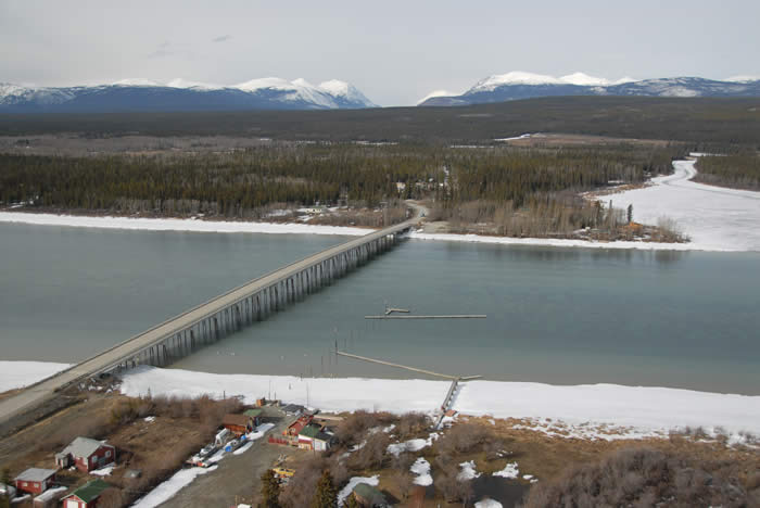
Yukon River Bridge, km 1393
A large viewing deck overlooks the beginning of the Yukon River, locally known as Lewes River Marsh. This is a wonderful place to take photographs. For an easy 1-day 12 km (8-mi.) canoe adventure, put-in at the boat launch of M'Clintock River bridge (km 1434) and paddle across M'Clintock Bay north-west to Lewes River Marsh. Waterfowl such as Northern Pintail, Canvasback, American Widgeon, and Common Merganser use this area for their summer moult. American Kestrels and Bald Eagles nest in the trees on the banks of the marsh. Look for beaver lodges tucked away in sloughs. Sometimes, Mule Deer or bears are seen feeding on the south-facing slopes. These are shy and secretive animals; you need patience and good timing to see them.
Aishihik Lake Campground, km 42, Aishihik Road
Wood Bison often come to the road north of the campground during the fall but move to the high country in the summer. These massive animals were re-introduced to Yukon in 1986 and an interpretive sign describes their habitats. Watch carefully along the road to the north for bison herds inhabiting meadows along the road. Many small ponds dot the landscape, making it a perfect habitat for waterfowl, moose, and wolves. Trumpeter Swans use the open water during spring migration. The road past the campground is not recommended for large vehicles but provides adventurous travellers with a 1 to 2-day wilderness experience.
Tachäl Dhäl Visitor Centre, km 1649
Excellent interpretive programs and videos are available when open mid-May to mid-September. Stop here to learn about Kluane National Park's flora and fauna. Viewing telescopes are set up to look for Dall Sheep on Sheep Mountain. This is sheep winter range so the best time to see them is late August to May. The face of Sheep Mountain has been designated as a special preservation zone. Check with the Centre staff for designated hiking areas.
Highway #2 - North Klondike Highway

Moose Creek Campground, km 560
A 2.5-km interpreted nature trail takes you into the boreal forest along Moose Creek to the Stewart River. You will require one hour to complete the loop trail. Note the change from dry White Spruce forest to floodplain willow. Listen for such floodplain residents as the Northern Waterthrush, Wilson's Warbler, and Common Yellowthroat. They feast on mosquitoes that hatch from the areas many small ponds. The return trail takes you along a dry ridge. Fishing opportunities are found along Moose Creek and at Stewart River.
Gravel Lake, km 622
This is an important wetland on the Tintina Trench, a major travel corridor for migratory birds in spring and fall. Just north of the highway pullout, a dirt road goes down to the lakeshore. Waterfowl nest here in early summer, joined by rafts of ducks in late summer. Because of its location on the trench, unusual birds are sometimes seen such as Ruddy Duck, Black Scoter and the most northerly sightings of American Coot. Yellow Pond Lily blooms carpet the lake surface in July. Sharp-tailed Grouse are commonly seen in the open aspen woodlands in this area.

Dezadeash Trail, km 245
A 3.5-km (2.2-mi.) trail takes you along the river's edge, through wetland and into the forest. This easy walk may reveal many species, from moose to ducks. You will need about 2 hours to walk the trail. This is a good location for winter wildlife viewing as the open water that can be found attracts a variety of wildlife. The parking lot and trailhead are on the Haines Highway #3, about 500 metres (0.3-mi.) from the intersection with the Alaska Highway. Look for the parking lot just north of the Dezadeash River, on the west side of the road.
Highway #4 - Robert Campbell Highway

Target Lake, km 41
A large pullout and a 30-metre (100') road on the east side of the highway is a good spot for a walk down to the water's edge. There is not enough room to turn your vehicle around at the end of the road. The large lake is alive with the sounds of songbirds. Yellow Pond Lilies cover the surface of the water in July. Many species of ducks and Red-necked Grebes nest in this wetland. This is the perfect place to sit and gaze across the lake at passing moose in the early hours of the morning.
The Faro Arboretum, 11 km, Mitchell Road, Faro
Less than a kilometre north of the turnoff to the Town of Faro, this site showcases native plants of the region. Interpretive panels about local flora and fauna, viewing decks complete with binoculars, sound posts and resting benches are all found at this site. Follow the 1.2-km loop trail from the kiosk, to the viewing deck, down to the west arm of Van Gorder Creek. Along the way, find out about plant species with the posted interpretive signs. Visit the Town of Faro or download Faro wildlife viewing brochures for more information on this Yukon wildlife viewing hotspot.
Mount Mye Sheep Centre, 8 km, Blind Creek road, Faro
Stay left on the Blind Creek road at the fork and you will end up at the cabin at the foot of Sheep Mountain. From this ideal vantage point, sheep are visible along the mountain side. The majority of the population uses this area October-May moving into the alpine areas of Mt. Mye in June. On cold days bring some firewood for the wood stove and enjoy the views from the comfort of the cabin. Visit the Town of Faro or download Faro wildlife viewing brochures for more information on this Yukon wildlife viewing hotspot.

Tombstone Interpretive Centre, km 72
The Centre offers staff and displays that can provide you with information on the natural history and recreational opportunities of the Dempster Highway region and Tombstone Territorial Park. The Centre is open seven days a week from mid-May to mid-September, including holidays. Campfire talks and nature walks are offered regularly. For a schedule of events, check the bulletin board in front of the Centre. A wheelchair-accessible, 1-km interpretive trail to a beaver pond starts at the souther end of the centre's parking lot. American Kestrel, Northern Hawk-owl, Wilson's Warbler, and Slate-coloured Junco are seen regularly in the campground. A 900 metre (0.5 mi.) self-guided interpretive trail introduces you to the tundra. Every summer, the Centre also hosts theme weekends with events and workshops on botany, geology, and the popular Weekend on the Wing birding festival (mid-June).
Blackstone Uplands, km 87-132
For the bird watcher this is the richest and most interesting area of the Dempster highway. Here you first encounter arctic species for which the highway is famous, such as Red-throated Loons, Long-tailed Ducks, Willow Ptarmigan, American Golden-Plovers, Long-tailed Jaegers, Common and Hoary redpolls, longspurs and Snow Buntings. Golden Eagles and Short-eared Owls are also common. The long-billed Whimbrel is often seen on the tundra to the east. Red Foxes and Woodland Caribou are often encountered in the summer.

White Mountain, km 9
White Mountain offers you an opportunity to view Mountain Goats. Scan the cliffs with binoculars or a telescope for goats perched high on the cliffs. If you want a closer look, watch for an interpretive sign on the east side of the road. Follow the road behind the interpretive sign. This road is an abandoned segment of the Atlin Road. It goes up the side of the mountain. At the highest point, there is an overlook of Little Atlin Lake complete with interpretive signs. Look up on the side of the mountain, goats often come down to this area to feed. A predator of goats, the Golden Eagle, also nests on these sheer cliffs. Look for their huge nests in the rock crevices.
Tagish Bridge Recreation Site
Located at km 22 (mi.14) from Jake's Corner or 37 km (23 mi) from Carcross, the Six Mile River flows into Marsh Lake and is easy to navigate. Waterfowl stage here in spring. It is one of the first places in Yukon where swans and other waterfowl appear in March. Located one mile north-west of the bridge is a Bald Eagle nest. The bridge can be easily accessed from the campground. You will find a boat launch at the Tagish Campground just east of the bridge. This area is known for its Lake Trout, whitefish, Least Cisco and Arctic Grayling.

Signpost Hill, Keno City, km 111
This area is renowned for its arctic butterflies, but there is far more to see. Collared Pika and Hoary Marmots and alpine birds such as American Pipit and ptarmigan are commonly seen. The Summit Trail, which can be driven, leads 10.5 km (6.5 mi.) to the milepost sign on top of Keno Hill. Learn more about alpine wildlife ![]() (504 KB) and trails in the area at the Keno Hill Alpine Interpretive Centre in downtown Keno by the Mining Museum. You can also download the trail guide Exploring Keno Hill: Stories of a Silver Deposit
(504 KB) and trails in the area at the Keno Hill Alpine Interpretive Centre in downtown Keno by the Mining Museum. You can also download the trail guide Exploring Keno Hill: Stories of a Silver Deposit ![]() (5.16 MB) on the wildlife viewing brochures page. Aussi disponible en français. Auch auf Deutsch erhältlich.
(5.16 MB) on the wildlife viewing brochures page. Aussi disponible en français. Auch auf Deutsch erhältlich.
Wildlife Viewing Guide
Copies are also available at Visitor Reception Centres and other Yukon highway stops. To receive your copy by mail, please contact Wildlife Viewing. To download your copy now, select one of the links below:

Contact Wildlife Viewing Phone: 867-667-8291 1-800-661-0408 ext. 8291 Environment Yukon Government of Yukon Box 2703 (V-5N) |